Toronto’s Waterfront: Hybrid Landscapes and Infrastructures of Desire, Ryszard Sliwka
“Nature is built into the fabric of the city, not just as a material element in urban space but also as a commodity that is integral to the abstract dynamics of capital accumulation” Mathew Gandy 2004
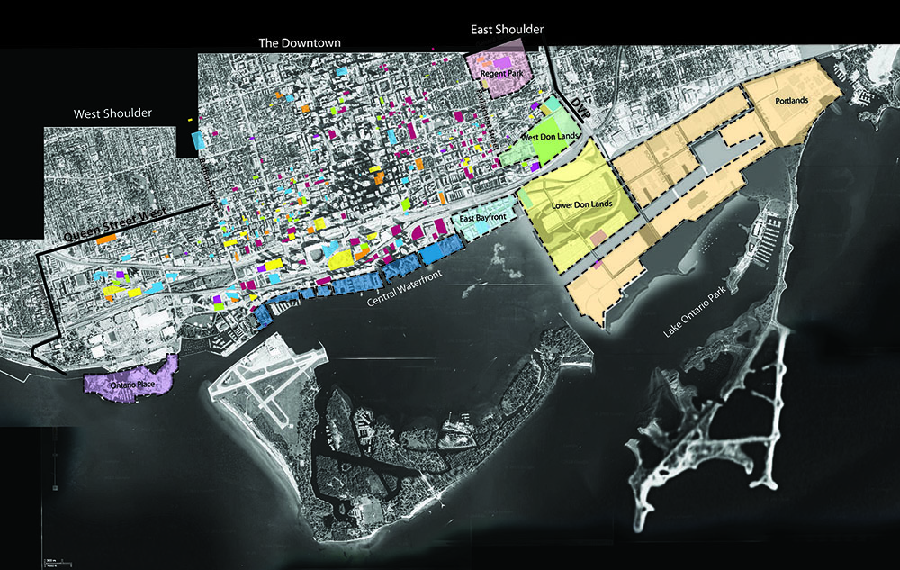
John Hartman’s iconic painting of ‘Toronto Shoreline Looking West’(1) (2007) [Fig.1] interprets the city as a living organism with major infrastructural arteries sprawling across the former industrial lands along the city’s waterfront. Here the human and the non-human exist in some intrinsic relation to each other, though not always in a balanced way. Much of this terrain is landfill built in stages to fuel the city’s industrial ambitions and extend deeper into nature’s “standing reserve,” (2) the luminous presence of Lake Ontario.
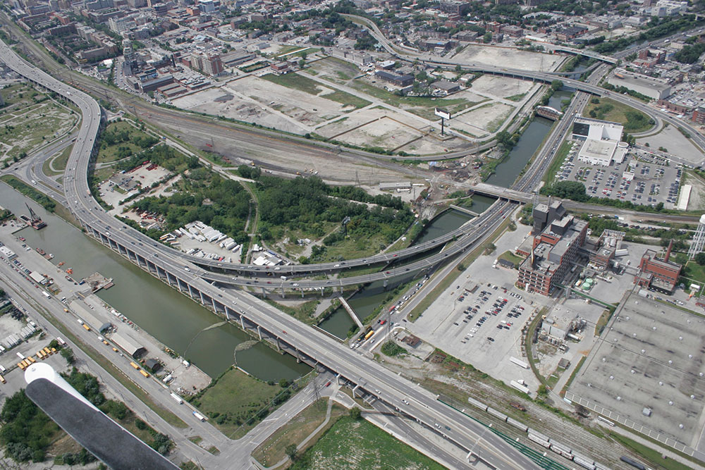
In the lower-middle foreground the industrial terrain of the West Donlands awaits transformation. Below it, a barely discernible thin grey line almost covered by pulsing vessels of highway and rail infrastructures traces the constricted channel of the Don River. The river, straightened as part of the as the city’s early 20th century industrial development, disappears abruptly into the Keating Channel, part of the port expansion that displaced one of Eastern Canada’s largest wetlands located on the mouth of the river’s delta.
If we look to the middle ground of the painting, a fragment of the Island airport appears on the left side, shaping the sharp edge of the western gap that opens up the inner harbor to lake beyond. The monumental silos of the former Canada Malting Co. [Fig.2] that mark the western limit of Toronto’s industrial waterfront are barely visible at this scale, but a little further west, closer to the western beaches, we can see Ontario Place, the first landfill project devoted to spectacle and pleasure rather than industry. While the central port facilities remained in active use, the cities recreational focus was to the eastern and western beaches as well as the Toronto Islands that border the Inner-Harbour.
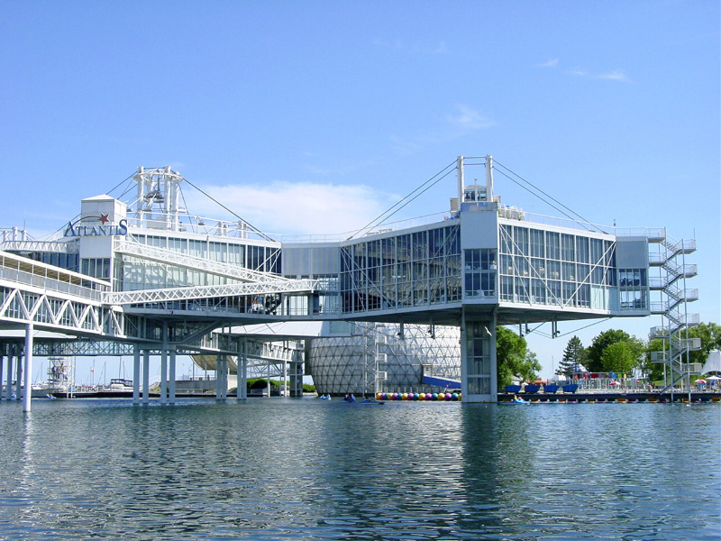
Ontario Place,(3) constructed on an artificial archipelago of islands in the wake of the euphoria arising from Montreal’s 1967 Expo, continues this recreational tradition and is perhaps the most radically optimistic juxtaposition of technological infrastructure and nature of the period; a place where ‘homo ludens’ reigns supreme, supported symbolically by the benign and conspicuous presence of modern technology. Viewed from Lakeshore boulevard, the festival like-atmosphere of this recreational spectacle bears an uncanny resemblance to a ‘Situationist’ photomontage of a sector of New Babylon(4) proposed by Constant (1971) in a utopian design for a new culture where work would be abolished and citizens could wander aimlessly and creatively across a labyrinthine terrain. [Fig.3]
The naturalistic landscape within which the Pavilions of Ontario Place are located was the work of landscape architect and educator Michael Hough, who hoped that the use of native plant materials would evolve into natural Ontario woodland over time. The prevailing cultural practice of the day however, maintained it as a scrupulously groomed ‘static landscape’ and it would be some thirty years before ideas of natural process would be brought to bear on the subsequent development of the eastern section of Toronto’s waterfront lands.
The construction of the railway corridor and subsequently the Gardiner expressway begun in the 1950’s changed the mental and physical map of the city as Toronto’s central waterfront became further separated both physically and psychologically from the public identity of the city [Fig.4]. This situation began to change in the early 1970’s as industry moved out and people began to imagine reconnecting the city with its waterfront once more. What emerged was a piecemeal set of interventions intent on preserving some of the surviving industrial heritage and prizing out pockets of public space along the waterfront, using cultural programming to activate the area.(5)
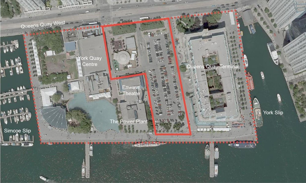
In the 1970’s and 80’s, the former industrial wharf of York Quay [Fig.5] was refurbished as an art and craft centre, an early concrete warehouse converted to residential commercial and cultural use and space was opened up for recreational events on a year round basis. To counter to an increasing wall of high-rise condominiums, more recent interventions juxtaposed stark timeworn industrial artifacts such as the Canada Malting silos with eclectic readings of landscapes such the Music Garden, 1999,(6) or HtO Park (2007). If a sense of lyricism and recreational tableaus shaped these topographies, the capacity of landscape to embody moments of trauma, offers a more sober addition to the collection of interventions. Ireland Park’s landscape of granite and bronze (2007),(8) located within the shadow of the Canada Malting addresses a moment in 1847 when over 38,000 immigrants fleeing the Irish famine arrived in a city with a population of 20,000 during a six-month period. Local hospital facilities were overwhelmed and about 1100 people succumbed to typhus or other illnesses.
It was not until 2006 that the succession of individual landscape interventions was supplanted by an agenda to establish a legible identity for the new waterfront. In an international design competition, the winning team, West 8 + DTAH proposed a “sustainable, ecologically productive ‘green necklace’ to bring coherence and continuity across the central waterfront lands as well as connecting the waterfront more directly back to the city.”
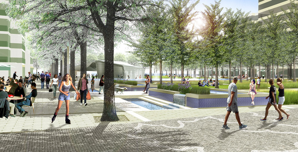
Two of the most significant recommendations are being implemented, namely a continuous water’s edge promenade, with a series of pedestrian bridges across the harbor slips and the ‘recalibration’ of Queens Quay as a tree lined Boulevard [Figs.6 and 7] and a secondary waterfront promenade with a new public decks created at the heads of the existing slips [Figs. 8,9, 10 and11]. At York Quay, the asphalt of the surface parking lot has been replaced by two squares that now connect the ‘green promenade’ of Queen’s Quay back to the Waterfront(9). [Figs.12 and 13]
East Bayfront and the West Donlands
The West 8 proposal overlaps and complements proposals developed for East Bayfront Precinct (Koetter Kim associates + Urban Strategies, 2005) located in the eastern part of the central waterfront lands. Here, one of the significant open space strategies is to establish critical view corridors linking existing north-south streets to the waterfront as well as reinvesting the waterfront promenade and the eastern section of Queens Quay as a tree lined public domains. [Fig.14] Here too a different paradigmatic shift towards technology and nature can be discerned, compared to the landscapes of Ontario Place developed some 40 years earlier. While the newly created Sugar Beach,(10) [Figs.15 and16] developed adjacent to the Jarvis slip, creates a surreal tableau opposite the Redpath Sugar refinery (the only surviving industry still operating in the inner harbour) the nearby larger Sherbourne Common(11) combines open space with splash pools that double as skating rinks in winter, yet is integrated with an ultraviolet (UV) facility for neighbourhood-wide storm-water treatment into its design [Fig17]. The ultraviolet treatment facility for the storm water management system is located in the basement of the park’s Pavilion.(13)[Fig.18] Collected storm-water is treated in the UV facility and released from three sculptural elements(14)[Fig.19] into a 240-metre long water channel and back out to Lake Ontario.
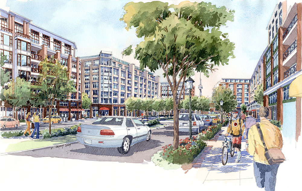
Immediately to the north of the East Bayfront Precinct, the Distillery District, (a former industrial area adjacent to but isolated from the core of the city and surrounding neighborhoods) connects to the newly constructed West Donlands Precinct to complete an integrated and extended public realm eastward from the city core to former industrial lands located adjacent to the Don River [Fig.20]. Like the East Bayfront Precinct the West Donlands (2005) planning document offers mixed programmatic strategies of housing (including some subsidized rentals) social, commercial and cultural institutions, together with the built form analysis of street sections that re-affirms in many ways the vision of the sustainable city that was the goal of reformers in the late decades of the 19th century. [Fig.21] Joseph Stubben’s classic ‘Der Stadtbau’ argued for instance that: “Stadtbau creates not merely the ground and the framework for the development of individual building activity: rather, at the same time, it is a comprehensive social activity for the physical and mental welfare of the citizenry; it is the fundamental, practical, public hygiene; it is the cradle, the clothing, the adornment of the city.” Stubben emphasized the social goal of city planning, whose ‘creations are for the poor as they are for the rich’. City planning participates in ‘equalising justice, a co-operation in the removal of social grievances and an influential co-operation in social appeasement and welfare.’ Joseph Stubben, Der Stadtbau, 1890
The illustrations in the original planning document anticipate a development that refers to Toronto’s brick warehouse and residential typologies [Fig.22]. The architectural character in the intervening period has changed significantly although the same basic planning strictures appear in place. Unlike City Place the project has succeeded in establishing links on its northern boundary with the construction of Underpass Park [Figs.23 and 24].
The West Donland precinct’s natural termination at the foot of the Don River however, has brought about an additional set of revitalization initiatives. Limits on the development of he city’s unique system of river ravines arose as a result of flood plain protection rules after Hurricane Hazel swept through the city in 1954, killing eighty-one people and causing $100 million in damage. Though most of the damage occurred in the Humber river valley, the Don Valley was badly affected particularly in the lower straightened section and silt washed down through heavy rains, requires constant dredging at the river’s confluence with the Keating Channel. The creation of a major park Corktown Common, located on a built up berm adjacent to the river, both reinvents the picturesque promenade using native plant species and functions as a flood-prevention measure to this lower part of the city [Fig.25]. The development of this open space and the subsequent proposals for the lower Donlands can be seen as part of a philosophical evolution intimated in Ontario Place in the early 1970’s but only fully articulated through publications such as Michael Hough’s ‘Bringing back the Don,’(1991) or coauthorship of the Waterfront Regeneration Trust publication Restoring Natural Habitats (1995), which voiced comprehensive strategies within the environmental community to revitalize the polluted Don River and other areas in Greater Toronto.
Lower Donlands Precinct
In 2003, Waterfront Toronto announced a plan to naturalize the mouth of the Don as one of four priority projects for the Toronto waterfront. It proposes to “re-establish a natural functioning wetland at the mouth of the Don River, while providing flood protection to approximately 230 hectares of land south and east of the existing Keating Channel.”
To date the environmental assessment process has identified a winning design by a team headed by Michael Van Valkenburgh Associates (MVVA) …using “ecological and sustainable strategies to ‘reintegrate strategically important post industrial landscapes while reframing their interactions with the natural environment. ” [Figs.26 and 27]
Both Ontario Place to the west of the central waterfront and MVVA’s urban estuary design at the eastern end, operate as hybrid landscapes that have a decisive social and technological engagement with ‘nature.’ The Lower Donlands proposal however, utilizes natural systems as a basis for re-structuring urban development rather than imposing an overtly technological human presence. By re-instigating a natural hydrological context for the river to function once more as a river, by creating a wetlands area and adjacent open space that can accommodate periods of flooding a new biophysical realm melds with cultural, recreational and living activities.
‘Boondoggle’(15) on the Portlands; an afterword
The Port Lands, which include the lower Donlands precinct, are the last major reservoir of land in the city, largely invisible to the public because of their ‘perceived’ inactivity.’ They encompass some 880 acres, an area as large as Downtown Toronto and 14 times larger than Canary Wharf in London.
An initiative in August 30, 2011, by the Mayor and his city councilor brother Doug attempted to wrestle away control of this area from Waterfront Toronto, the inter-governmental development corporation charged with activating the former industrial lands. The Ford brothers’ new vision for the Toronto Port Lands was presented to the City's executive committee, who put its support behind transferring oversight of the area from Waterfront Toronto to the Toronto Port Lands Co. (TPLC) under the direction of architect Eric Kuhne. The consortium envisioned a developer driven “Las Vegas-like remake” of the former industrial area, converting the former Hearn electricity generator as an ice palace, (complete with observation deck where the smokestack is now located), providing a super-mall and an “emerald necklace of green-space encircling the area;”(16) The project’s formal rhetoric blends massive commercial and residential development with a desire for urban spectacle, replete with a monorail and giant Ferris wheel in a way that resonates with the sentiments that led to the creation of Ontario Place so many years ago. The opposition generated by this proposal however, was one of the more remarkable acts of civic engagement by the public in recent history. The TPLC project for the most part ignored the years of environmental assessment and public consensus that recognized the need for open space, biotic systems and ecological infrastructures as integral to the planning process. While still fragile, it seems that this vision of metropolitan nature, has grounded itself in the public consciousness of the city.
Ryszard Sliwka teaches Design and a Cultural History course on Modernism at the University of Waterloo where since 2006 he also directed a Graduate Studio on Contemporary European Design and Urbanism based in Rome. Prior to teaching he worked in practice for a number of years on a number of large urban interventions and award winning projects, both in North America and Europe.
He writes on contemporary art, architecture and urban issues and is currently working on a painting series drawn form an interest in narrative and broadly defined as conditional abstraction.
NOTES AND CITATIONS
[1] Hartman John, Toronto Shoreline Looking West, 70x76 inches, oil on linen
[2] The term is taken from Heidegger's critique of modern society's perception of technology and communicates something of the historically based ambivalence that Toronto's industrial and urban development to its own environment. Heidegger felt that modern technology for the most part viewed the entire world as an undifferentiated "standing reserve" available for any use that humans chose to put it rather than something with it's own intrinsic properties.
[3] Operating between1971-2011, (Ebehard Zeidler Architect)
[4] http://www.megastructure-reloaded.org/constant/
[5] Selling parts of the land for residential and commercial development paid for the cost of these cultural initiatives.
[6] The design is an interpretation of Bach's Suite No. 1 in G Major; a collaboration by the cellist Yo Yo Ma and landscape designer Julie Moir Messervy, together with landscape architects from the City of Toronto's Parks and Recreation department.
[7] HtO park is an abstracted landscape of grassy dunes and rectangular fragment of sandy shoreline set within the harbor walls fronting onto the lake. Janet Rosenberg Assoc. Claude Cormier, Hariri & Ponterini Architects
[8] Kearns Mancini Architects
[9] MVVA Associates
[10] Claude Cormier Architectes Paysagistes Inc.,2010
[11] landscape architects Phillips Farevaag Smallenberg, 2010,
[12]http://www.waterfrontoronto.ca/explore_projects2/east_bayfront/waters_edge_promenade_and_stormwater_management
[13] Teeple Associates Architects, 2010
[14] “Light Showers” by artist Jill Anholt
[15] A boondoggle is a project that is considered a useless waste of both time and money (Wickepedia def.) The term was used scathingly by councilor Doug Ford to describe the Waterfront Toronto Agency.
[16] Flack Derek, New Portlands vision moves one step closer to fantasy, blogTo, Sep 7, 2011 http://www.blogto.com/city/2011/new_port_lands_vision moves_one_step_closer_to_fantasy/
Elliot Matt, On the Waterfront: swapping green space for development lands a lousy trade, Metro, April 5 2012, http://metronews.ca/news/toronto/61563/port-lands-update/


EWT/ EcoWebTown n.7
Magazine of Sustainable Design
(Quadrimestrale on line sul progetto di città sostenibile)
Edizione SCUT, Università Chieti-Pescara
Registrazione al tribunale di Pescara n. 9/2011 del 07/04/2011