 Is There a Green Sustainable Urban Design Narrative?
The Evolution of the Central Pickering Urban Experiment in the Greater Toronto and Hamilton Area
Val Rynnimeri
“In every city there are individual personalities; every city possesses a personal soul formed of old traditions and living feelings as well as unresolved aspirations. Yet the city cannot be independent of urban dynamics. Behind the particular cases there are general conditions, and the result is that no urban growth is spontaneous. Rather it is through the natural tendencies of many groups dispersed through the different parts of the city that we must explain modification of the city’s structure.”
Aldo Rossi, Architecture of the City (1)
As Also Rossi wisely noted in his underappreciated fourth chapter of the “Architecture of the City”, city building is a complex, unpredictable activity involving many actors, driving many processes, and with many motives. That outlook is central in shaping Rossi’s description and explanation of how and why urban transformations, especially those of the urban architecture, occur in cities. Toronto in the post-World War Two years is typical of North American cities under such great expansion and transformation pressures. Such pressures and processes are still very much in play in the much expanded Toronto of today, and will always come to some kind of formal fruition in city building but, in Rossi’s view, the eventual result is not foreseeable by planning, and is not even a clear target for policy.
With Rossi in mind, this presentation of the Central Pickering project on the eastern periphery of the Greater Toronto and Hamilton Area (GTHA) is not about outlining a particular exemplary design solution for the green city, one to be put into place universally in a multi-phase work as is the usual hope of urban designers. There is no formal, technological, or functional design truth for Central Pickering, only a kind of systems narrative of forty years; of pushing an ever-changing body of community ideas forward, ideas now almost unrecognizable from their first iterations in the 1970s, and ideas greatly added to. The Central Pickering project of today carries the baggage of decades of design and discussion, and it is precisely that baggage accumulated over decades that may prove the real lesson in creating a green community and even the more generalized urban field of the green metropolis. In all, I believe that this is how to build green communities.
The creation of the green urban fabric of the Central Pickering project over four decades is what systems theorists call a “wicked problem”, a problem that is complex, intractable and always evolving out of its potential solutions before they can be implemented.(2) The project narrative is presented here not as an idealized urban design solution but rather as a possible alternative narrative to the problems bedeviling a lot of green projects as they move from concept to realization: the slowness of political uptake, the compromise of ideas by private development pressure, the inertia of older ideas and methodologies in the process of acceptance, and the shockingly fast obsolescence of not only technologies proposed but of the very design ideas underlying the new work. Examining the four decade evolution of the Central Pickering plan, I propose a different, longer term, co-evolution of planning, land development, regional and local politics, and informational methodologies in making the urban designs of new green areas realizable. The green city, or metropolis, is always going to be long term work; a project characterized by increasing complexity and sophistication, and that increase itself continuously increasing. Only by embracing that process of complex urban dynamics, can the future sustainable community come into being, or can design even have a chance to compete with history on the move, and to have any success in shaping the destiny of a city. Such “wicked” design situations are inherently irresolvable but still need to be continuously monitored and ongoing solutions kept in the works, or any vision for a good city of the future is truly lost.
I propose that in a workable theory of the green city, urban dynamics is far more relevant than urban form, even landscape form. To be realistic, at the metropolitan scale of the GTHA, the metropolis versus the city proper, the layered complexity of the urban field makes even thinking of a finite realizable city form for even the most recent version of the Central Pickering Project pointless. This has not always been the case in the Toronto region, at least since the mid-1960s with the proposal of the Erin Mills new city model. Erin Mills, built on farmland west of the city, was initially developed by the same corporate group that had just completed the pioneering 1950 suburban new town of Don Mills with its 30,000 inhabitants. Before construction, it was sold off to a part of its original creator group for a long term completion that was to last into the mid-2000s, twice its anticipated build out timeline. Toronto urban thinker and former mayor, John Sewell, argues in his “Shape of the City”, that Don Mills set the standard for post war suburbanization, not just for Toronto but for all of Canada.(3) This view is only slightly mistaken; it was Erin Mills, following closely on Don Mills’ corporate success, that created the concept of the suburban development field, an interwoven set of infrastructural, social and natural space networks that became the model for the GTHA’s more generic form of suburbanization. It was this model that was also transposed across Canada as a model for the massive suburban building of the 1970s up to the 1990s before it was even questioned as to its correctness.
Erin Mills as the First Try for a Green Infrastructure in the Metropolitan Field
Erin Mills began as a set of two new cities, Meadowvale and Erin Mills, located west of the City of Toronto in the West Credit Development Area. The new two urban areas formed a north-south line connecting the three major superhighways, two already built, planned to the west of Toronto. The development goal was a total target populations of 170,000 on 8,000 hectares. As they were built, the two communities together quickly became the basis for a much larger metropolitan field which was to eventually encompass the entire suburbanized area of the Greater Toronto Area (GTA), east and west, due to the ease with which the new land development system handled all corporate urban development speculation. (Fig. 1) This was already clear to its creators in its initial proposal document,
“Erin Mills will not be a “new town” in the classic British or Swedish sense, primarily because it will be an integral part of the metropolitan development area rather than separated by it from a wide belt of open countryside.”(4)
With quick buy-in by the Toronto regions municipal governments Erin MIlls became, in a simplified form, the de facto and unquestioned urban planning spatial and functional field for the next forty years, and it continues today in an adapted form. The Erin Mills system solved the problems for all the land development actors in the GTA’s urban expansion over four decades, and, naturally, its land system became the underlying form of all the Central Pickering projects since the 1970s.
Ironically, Erin Mills itself began with a rich and sophisticated green strategy for its open space systems. These were developed by Robert Dorney, who would found the University of Waterloo Faculty of Environmental Studies, and Fraser Watts, an architect/landscape architect who became the Director of Waterloo’s School of Architecture in the early 1970s. The green strategy was based on an interwoven community greenway system developed from the site’s original watercourses and farm woodlot forests. As well a larger metropolitan green space system was proposed paralleling the lines of major infrastructure like expressways. (5) Sadly after the first Erin Mills phase, both systems were slowly leached out of any further planning and, as civil engineers took over the momentum of building, the green system spaces only remained as remnant natural landscapes for storm water corridors. The complex Erin Mills ecosystem foundation for its land development system was slowly eliminated or simplified to become land use, urban servicing, and transportation based, a truly effective planning structure to satisfy municipal planners, an efficient land development machine for the private land development industry, but a poor natural green space system. (Fig. 2)
The Central Pickering Timeline to 1995
Initially planned in 1972 as a Modernist suburban garden city of approximately 150,000 to 200,000 inhabitants, and a mirror in location and size to Erin Mills, North Pickering, the original name for Central Pickering, was to be located on a land assembly of 10,000 hectares, then expanded to 17,000 hectares, expropriated by the Province of Ontario to the east of the urban area of Metropolitan Toronto. To the north was an even larger Federal (national) government land assembly earmarked for a new international airport. North Pickering was intended as the adjacent new town to that new second international airport for the City of Toronto. A master plan, “The North Pickering Project – Recommended Plan”, was proposed by the Province for its lands in 1975. (Fig. 3) Much of that urbanization work was focused on first developing the eastern half of the Ontario land assembly with a new town of 75,000 inhabitants. The rest of the provincial land assembly was earmarked for two green corridors surrounding the new community, and was to developed along the western and central branches of Duffin’s Creek, the new town’s main waterway. There was also a large area, well over half the assembly, to the west of Duffin’s Creek slated for an agricultural preserve preserving existing small agricultural communities. (6)
With the subsequent suspension of the second airport’s development shortly afterwards due to extensive opposition from the local communities, and coupled with the ensuing government tendency to now favour expanding the existing international airport west of Toronto, the North Pickering plan’s development languished for over ten years until it was picked up again in the March of 1990 by the Province of Ontario Ministry of Housing. The new initiative was assigned internally to its Seaton Interim Planning Team (SIPT), a team of selected provincial civil service planners led by Tom Zysys, a political operative seconded from the Premier of Ontario’s office. The major political concern of the late 1990s was a perceived crisis in providing affordable housing in the GTA, and there were several such planning teams initiated for the entire series of Ontario land holdings throughout the province. (7)
In the intervening ten and a half years, almost half of the original 1972 North Pickering lands had been re-assigned from the original assembly. The large land portion, to the west of Duffin’s Creek, had become the Ontario Agricultural Preserve in response to the public perception that Toronto’s low density urban sprawl was paving over some of the best quality agricultural soils in Canada. Also portions of the land assembly in the Town of Markham were sold by the government’s Ontario Realty Corporation to private developers in that town, and some of the most western river corridors areas were assigned to a new massive Rouge River Valley natural waterway preserve. The contentious North Pickering community plan for 75,000 had not happened at all. (8)This time the planning proposal that evolved for the Pickering site was for a much smaller but still substantial new town of Seaton with an anticipated denser population of 90,000 on the original eastern half of the 1975 plan. The area of the new Seaton was approximately 2800 hectares but 7,000 hectares when combined with the anticipated green spaces in its fabric.
As part of the renewed SIPT initiative on the urbanization process, a new imperative for the new town to be a green sustainable town was added to Seaton’s original urban programme of housing and new incubator industry. In the 1990s under Liberal and NDP (socialist) governments, there was an especially important policy mandate to provide affordable housing with employment nearby, this to avoid the extensive commuting now threatening automobile gridlock in the Toronto urban region. As well, with increased co-operation with the Region of Durham and the Town of Pickering, a desire for creation of a new expanded Durham College was proposed as the institutional heart for the new town centre. (9)
In the 1990s, looking for an alternative to the Erin Mills model was clearly in the air. From 1989 onwards, the SIPT worked with a broad range of private sector advisors and with the three Toronto area universities with planning and design programmes, the University of Toronto Landscape Architecture School (U of T), the Ryerson Planning School, and the University of Waterloo Architecture School (UWSA), of which I was the lead participant. During that period, Geographic Information Systems (GIS) databases for the area were constructed, this activity driven especially by Professor Rob Wright of the U of T Landscape School in consultation with private consultants. This pioneering role of GIS to create an underlying database was a key new urban planning tool and methodology especially in connecting critical information between ecosystem factors, human systems, and infrastructure factors. Social planning was Ryerson’s main role in the experimental work through Prof. Michell Kosny. My role was to advise on innovative housing and urban design strategies, and to run urban design studios at the University of Waterloo testing such future scenarios for Seaton. At the time, as part of my work at the MBTW firm in Toronto, I also did extensive work private work with the region’s suburban land development industry, the hoped-for purchasers of Seaton’s lands, and I am sure my inclusion in the advisory group was based on that fact as well.
After a couple of years of back and forth discussion and analysis, and the 1993 creation of the broader community based Seaton Advisory Committee to lead the future implementation, the Seaton project was finally the basis for a three stage international design competition held in 1994. By now, in the intervening decades, Toronto had become the Greater Toronto Area and its expanding area of urbanizing periphery had grown out to Seaton’s land assembly, thereby placing the original 1975 new town concept in some doubt as a realistic development framework for the future. This impending envelopment by Toronto’s eastward sprawl at least raised some doubts in discussions but was never brought forward in the competition by any of the competitors. The affirmation of the agricultural preserve did guarantee some containment of sprawl but was not yet part of a broad GTA strategy. Nonetheless, the “Seaton Design and Planning Exercise” competition went ahead through two open stages and then a remunerated short list stage. A new town concept for 90,000 people developed by the Ontario Form Collaborative (OFC), a multidisciplinary group led by three Toronto area firms was the eventual competition winner. (Fig. 5)
The 1995 Master Plan for a Green New Town
The group of architects, urban designers and landscape architects in the OFC design team, of which I was one of the main designers, chose not to challenge the expectations of a new town solution. (10) We wanted to win the competition, and with a realizable scheme. Despite the plan’s conservatism in not challenging the provincial client’s desire for a new town, our winning proposal had many innovative features like a strong green infrastructure network to be evolved over time, and an early version of self-organized incrementally developed urban districts and streets. These features were developed on the back of the GIS developed by the SIPT. In the early stage of the competition, our team created the Seaton urban plan as a set of layers, each with their own structural logic and form. Such layers like natural systems, heritage areas, and road networks were layered to look for opportunities in the urban networks for enhanced urban interactions. The desire was to create a complex self-organizing community. The ecosystem rehabilitation and regrowth strategies were built on the GIS layers for critical ecosystem issues. (Fig. 5 and 6) In turn when combined with community and local park needs, we were able to see the opportunity to combine all the disparate systems into a new community wide network of green infrastructure, one that would grow over time. (Fig. 7) Green infrastructure, a big influence on our planning process, was itself a concept only then being promoted by the US Department of Agriculture and its pioneering studies of green corridors.
Such open-ended incremental strategies were also applied to land use in our plan, the result of which was the creation of complex multi-use “workshop” streets, combining higher density residential types with green workplaces in walkable relationships. (Fig. 8 and 9) Agriculture was seen in this light as well, especially since project leader John Van Nostrand was deeply committed to its survival, not only in the agricultural preserve, but also in Seaton itself as the new community would grow. For Van Nostrand, as the farm land would urbanize in our plan, it moved in land use from working farms, to allotment gardens, to urban neighbourhoods.
The 1994 Seaton plan itself was a hybrid of these new GIS based incremental strategies and more conventional planning. The latter was used where there was no benefit in challenging a status quo, and occurred in the road systems and in the urban servicing. For the servicing, it was simply because Durham region already had the sewage capacity to handle our new town’s sanitary needs, and for our roads, we felt we needed a central boulevard and a conventional town centre to declare the new town’s identity as a separate community with its own expressway exit. (Fig. 8) Where we could, we were able to locate innovative features like reconstructive wetlands to process storm water from roads and streets. This was a hybrid project that was designed to win the competition and carry us forward into a future of city building in the next years. (11)
The Conservative Interregnum, Loss of Purpose, and the Seaton Land Exchange
The momentum of the North Pickering project, now named Seaton, looked promising in late 1994. (Fig. 10 and 11) Over the next ten years, however, it became the quick victim of elections and changes in governments and a confusion of purpose. With the defeat of the more socially motivated, and Seaton friendly, provincial NDP party in the 1995 provincial election, and its replacement by a “common sense” Progressive Conservative government, the project ground to a halt in the face of the new government’s promise to cut taxes and shrink government. All the north Pickering lands became a political opportunity for the new government to raise the cash it needed for its tax cutting agenda by selling provincial land assemblies along with other assets. As politicians debated, Seaton’s now valuable lands were seen by them as opportunities for immediate sale with the profits put against the provincial debt.
To further entrench political good favour, in 1999, the agricultural reserve was sold back to the original owners or leased to tenant farmers for their use. (Fig. 12) A land use restriction limiting their use to agriculture in perpetuity was maintained, however. (12) There were attempts to sell some of the urban land for immediate land development bu,t as there had been no official acceptance of the 1994 master plan, there still remained the need for a new, and longer, planning process. The Seaton lands thus were incorrectly zoned as the original agricultural uses, and had no value added opportunity for the Ontario government. They would have had to be sold at low market prices for un-zoned or agriculturally zoned land. This lack of a large windfall profit stymied the sale of the lands as the government realty corporation sought to find some way to realize the development potential and retain the windfall profits from speculative sale. So, the project languished again for almost seven years under a political regime with limited purpose vision. In its last years a new agenda for Seaton emerged in 2000 to 2002 from an unlikely series of events but one which proved prescient for the future of North Pickering.
By 2000, the GTA’s urban area had started to encroach on a land area which was probably one of the ecologically most sensitive in the GTA, the Oak Ridges Moraine. These lands on the GTA’s northern edge, partly just to the north of Seaton, were a glacial moraine running east-west across the top of the mega city which acted as the geological “sponge” for the entire northern metrpolitan region’s groundwater recharge. The moraine released its groundwater more slowly than normal surface flows, and especially more slowly that urban surface flows, thereby ensuring the base flow of the entire GTA’s urban rivers and creeks.
Developers had begun assembling land in this area and were now seeking re-zoning for the large homes of high end residential communities. Facing a “land rush” in this environmentally sensitive area, the provincial government pulled out of its planning lethargy and, being conservative, created a task force to find a solution that sought not to deny developers their speculative due. The result was the North Pickering Land Exchange Review Panel (13) which turned to the Seaton lands for its solution, a compromise which was quite simple. The government would preserve the moraine lands in their natural state by offering an exchange of Seaton lands for the moraine properties to the north on which the developers were trying to build. The ad hoc nature of the exchange did have an interesting effect, however. It raised the larger issue of protection of sensitive urbanizing areas as a political debate in the upcoming 2003 provincial election, and it served to unlock the stasis into which the Seaton project had fallen. This was the last planning decision for Seaton by the Conservative government.
Big Moves in Ontario
With its first decisive initiative following the Liberal victory in the election of 2003 the new Ontario government overturned eight years of no movement in any aspect of environmental policy and moved immediately after the election to create a vast greenbelt surrounding the Greater Toronto and (now) Hamilton Area. The greenbelt was initiated as an amalgam of many policy initiatives from many actors: protection of natural areas, especially areas of recharge for the bioregions many urban rivers and creeks, preservation of agricultural lands, containment of low density urban sprawl and its ballooning infrastructure costs, gridlock created by an over dependence on automobiles in a low density urban fabric, containment of land development forces in order to create a second wave of urban intensification in existing low density communities. (Fig. 13)
Largely, however, the greenbelt was the consolidation of three large areas of non-urbanized Ontario, the Niagara escarpment and its UN world biosphere status, the remaining Ontario countryside threatened by sprawl, and the Oak Ridges Moraine. All of the above lands were to be interlinked with new areas and corridors of forest, wetland and open field ecosystem rehabilitation to ensure future complex, and eventually self-generating, urban and regional ecosystems. Most importantly, this was all to take place while urban development and intensification built new communities and allowed older places to intensify the uses and physical fabric of their urban areas.
The broad goals of the Ontario Greenbelt were a province-wide reflection of the environmental goals for the Seaton 1994 plan, almost as if the Seaton project had been a laboratory for the larger Greenbelt: the maintenance of the health of the natural environment for the region’s surface and ground water systems, support of corridors of natural open space for people and wildlife, the support of vibrant agricultural communities and the support of agriculture as a broad-based source of commerce, jobs, and food production, and the provision of outdoor recreational opportunities for urban and rural populations.
For the purposes of future land development, three broad grades of urban land were created by the Greenbelt Act, the pre-existing urban lands of the GTHA, the newly classified greenbelt lands with restricted urban development, and the still undeveloped urban areas known as the “white lands” (from the colour on the Province’s conceptual map). The “white lands” were the remainder of agricultural lands inside the green belt where land development was still allowed. There was also land development allowed in the green belt for the intensification of existing urban areas. Seaton and its larger area became the one of the last large open areas of “white land” remaining inside the greenbelt and, combined with the North Pickering land exchange deal of 2002, this proved important to the future of the now re-named Central Pickering.(14)
A Place to Grow: Central Pickering in the Greater Toronto and Hamilton Area Urban Field
There was a final political battle between 2002 and 2006, with two competing plans for the Seaton area, one by the Ontario Ministry of Housing and the other by the Town of Pickering. Pickering was the municipal area of which Seaton had always been a part, and one of the easternmost of the GTHA communities. (Fig. 14) The Town took on itself the task of sorting out the upshot of the Land Exchange. In doing so, it tried to put new development plans, not just on Seaton, but on the Agricultural Preserve as well. In its North Pickering plan, the southern reaches of the preserve were to be developed at the same intensity as the Seaton lands, a great difference with Provincial policy and an approach which would create a bonanza of new land for developers. (Fig. 15 and 16) This was a battle for Pickering to lose, however, in the face of the two massive planning initiatives by the Province of Ontario after the Liberal election victory. The first, the Green Belt of 2003 as we have seen above, was radical enough and protected the agricultural preserve as an area of farmland with agricultural hamlets, but the second initiative, “Places to Grow” of 2006, expanded the conceptual framework of the Greenbelt to all aspects of planning for the Greater Golden Horseshoe (GGH) around the western end of Lake Ontario. The new initiative was a comprehensive re-examination of Southern Ontario’s future, and today is still the template of any future development in Southern Ontario.
Looking at “Places to Grow”, one could also easily speculate that the 1994 Seaton plan was the laboratory for the new 2006 policy initiatives now reaching across the province. In ‘Places to Grow”, the Greenbelt is set as one of the main frameworks for a vast metropolitan region, a megacity of the Greater Golden Horseshoe (GGH) stretching around the western shores of Lake Ontario from Bowmanville east of the GTA, west to Buffalo in the US. The GGH also reaches its networks out west through the Greenbelt to the cities of Kitchener-Waterloo, Guelph and Brantford, and north to the cities of Barrie and Orillia, the near gateways to Ontario’s northern ‘cottage-land’ communities. (Fig. 17) Added to the Ontario Greenbelt are layered systems of high order transit balanced with expansion of highway networks along new corridors linking existing cities and extending west to trade corridors with the United States. Locally, there is a growth emphasis in intensifying the urban areas of existing communities, creating walkable communities not reliant ton automobile traffic. Agricultural areas and production are preserved and enhanced forming a pillar of Ontario’s future economy. Finally, there is again a proposal for a second international airport on the eastern site that was earmarked for it in 1975. (15)
Today, Seaton itself is now the central area of a larger Central Pickering planning area in that “Places to Grow” Ontario future. The passing away of the new town concept has had a valuable result, however. Looking at the recent Central Pickering Development Plan (CPDP) of 2006, it’s clear how outdated the original 1975 new town and the urban parts of the 1994 competition winner were as a general concept for a metropolitan urban structure. The 2006 CPDP was created by the Province of Ontario Ministry of Municipal Affairs and Housing in consultation with Durham Region and the Town of Pickering by the planning Alliance, the planning firm of the original 1994 Seaton Competition winner’s project leader, John Van Nostrand. After a wide consultation with the community, the development industry, and a range of sub-consultants, Van Nostrand has clearly continued as the planning leader and has been the continuity throughout the decade-long timeline of Seaton’s development narrative. (16) It’s instructive for the future of GTHA planning to see what was left out from earlier Seaton design concepts, and what ideas were kept from the 1994 scheme. It’s also important to see the affect that the 1994 competition “thought experiment” had on the creation of “Places to Grow”, as a generational shift took place in the planning profession and its culture during the wasted years of the Conservative government.
In the new 2006 Seaton plan in the CPDP, the 1994 competition winning scheme has been transformed to become a new green version of the ubiquitous suburban planning field of the “Places to Grow” GGH metropolitan area. (Fig. 18) The innovative ideas (in mid 1990s terms) of the competition winning Seaton new town, like the green infrastructure, have been kept, expanded, and interwoven with the larger GGH green networks now protected by the Greenbelt Plan. (Fig. 19) Seaton’s urban forms, however, like the 1994 town centre and the central boulevard have either been transformed, relocated, or have disappeared. The new network and urban field based Seaton community of 2006 is the future of the evolving development of the enormous metropolitan field of the GTHA, an evolution of the metropolitan idea that Erin Mills began in the 1960s, and where Erin Mills is in turn situated on the 19th century British Imperial survey grid originally created for the settlement of Upper Canada, Ontario’s original name. All those layers in turn sit on the biotic and abiotic natural forms like the Carolinian forest, the Oak Ridges Moraine, and the Niagara Escarpment. (Fig. 22) All the natural systems, to varied degrees of permanence, still endure below the layers of human development. This is the GTHA and even the GGH urban field, and this layered structure is the basis of an ecosystem approach for planning the metropolitan urban region.
A the new layer of this deep urban form, the four decade Seaton experiment has been a success, as its ideas have been generalized as future lessons for the bigger urban and suburban areas of the GTHA. This network quality is seen most clearly in the 2006 plan road network for Seaton and Central Pickering. (Fig. 20 and 21) The central boulevard of the 1994 Seaton new town is gone, and the new road network is continuous with the broader metropolitan road framework. There are still centralized urban areas in the plan but they are reduced in scale to local neighbourhood centres and framed by an increase in land use complexity and density, and are not traffic based like the original scheme. As well the higher commercial concentrations on Taunton Road to the community’s south are more metropolitan in scope and suited for the regional city rather than being specifically Seaton based. In all this re-shuffling, Seaton has been lost as a new town, but has become more deeply engrained in the metropolitan urban field.
There is a space/time scale to such a dynamic conception of urban projects that replaces the formal conceptual clarity of the big idea with a process of evolving formalized structures and strategies. This is especially true of green sustainable projects that transcend generations of designers and planners due to the very nature of growing out a complex ecosystem, one like the Ontario Greenbelt. In this period of climate change anxiety that did not exist when it began, Erin Mills took forty years to build out. The GGH and Seaton will probably take as long and will probably change some more, a lot more. We are not over re-considering the future impact of climate change and the depletion of fossil fuels. The conceptual clarity of the Modernist plan for Erin Mills was built on a forty year illusion of cheap energy that, despite Erin Mills’ completion, now has an unclear future. Technology and society today are transforming faster than was possible forty years ago, as are modern economies. The “Places to Grow “ plan for Ontario tries to anticipate all of the above trends but even forecasting them is mostly luck.(Fig. 23) At least by encouraging a set of opportunistic, self-organizing, and robust urban networks, green ones, social ones, and technological and infrastructural ones, the plan enables a wide metropolitan urban field. Here, the future city can be given an opportunity to grow incrementally and with a kind of open-ended evolution. That’s the lesson of the forty year Seaton project for the green city, not to create a perfect green urban machine the first time, but to place its future in a complex networked process of guided self-organization like Rossi alludes to at the beginning of this article. The best result then for such a future is one that arrives at that ultimate goal of good urbanism, surprise, and if lucky, a good one.
A Postscript on Other Planning Approaches Considered for the GTA in the 1990s and 2000s
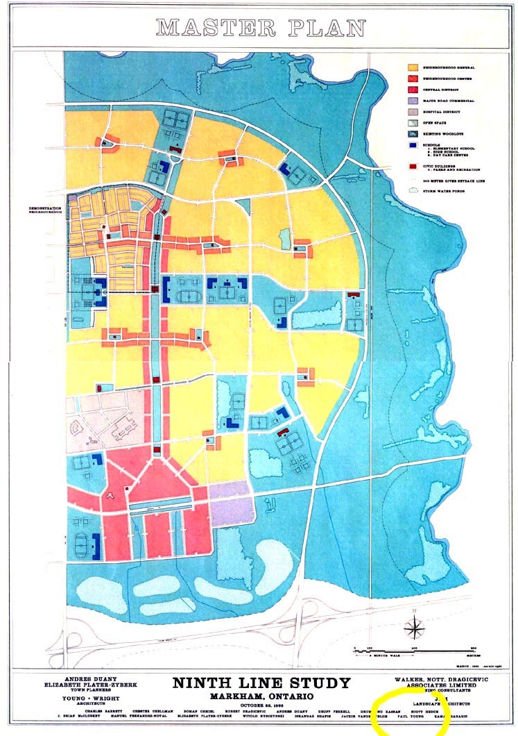
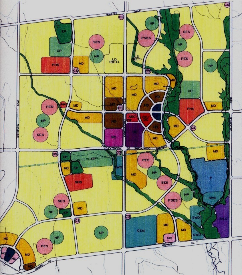
There needs to be a brief afterward note added on the impact of New Urbanism and Landscape Urbanism planning approaches when evaluating the flow of new ideas into the “Places to Grow” plan for the GGH. New Urbanism came on the planning scene at the same time as the work being done on Seaton in the early 1990s. Its initial planning project, oddly enough, was located on the lands assembled by the Province of Ontario in the Town of Markham just to the north east of the Seaton land assembly. Some of the lands in that assembly had originally come from the 1970s assembly and had been transferred to the Markham municipality due to their being inside its boundary. Under Markham’s guidance, the Florida-based New Urbanist planning firm of Duany Plater Zyberk (DPZ) was selected to produce the plan for a new town, eventually called Cornell, inside the Markham boundary. The eastern edge of the new community was to be the new Rouge Valley Natural Area. The Town of Markham, a historical 19th century village surrounded by Erin Mills style suburb, was itself was located to the west. Altogether this location was a real hodge-podge of planning. A conceptual plan, nonetheless, was developed by DPZ during 1993-94, one looking very much like a Parker Unwin plan of an early 20th century new town like Letchworth; in all Cornell was a very well planned New Urbanist community, one intended to fit, since it was in Canada, into an early English new town-like image with its commercial high street of apartment above shops, common greens based on schools and other institutions, and mixture of row houses and detached single family homes. (Fig. 24)
Cornell was the first of many attempts at creating a New Urbanist project in the GTA, some by DPZ and some by local planners and architects. In 1990 and 1991 this author created two New Urbanist plans for two MBTW clients both in the City of Brampton in the GTA to the north-west of Toronto. One, “the Healthy Village” was intended to be an alternative to the Erin Mills system itself and was a commissioned research project. The other was a master plan for new 50,000 person town called Fletchers Meadow on the very edge of The GTA urban periphery. (Fig. 25 and 26) In reality, that project was an attempt by the developer to create a “buzz” around the new community so it would be included inside the urban boundary by the City Of Brampton. Following the real estate crash of 1989, however, there was also a serious interest by nervous developers in looking for new alternatives to community planning.
Over the following years, all the projects named above suffered one of two fates, and those fates were matched by almost all of the New Urbanist communities planned for the GTA. The most merciful fate was to be cancelled, like the Healthy Village, when it became evident that approvals designed around any new ideas would drastically increase the time line for municipal development approvals. For private developers speedy predictable timelines are sacrosanct. The second fate was what occurred to Cornell, Fletcher’s Meadow, and others like Oakville North; they were swallowed by the Erin Mills planning system as local anomalies with key parts of their concepts (like the high streets) substantially relocated to arterial roads as the usual shopping centres and business parks, and the intimate reduced street rights of way left large and expansive as in conventional suburbs. What remained were the traditional looking houses with their front porches and a small token reminder of a mixed use village centre with only a few retail shops.
Cornell does not appear today in the DPZ website among the comprehensive list of the firm’s projects, and it seems that it has been excised from the firm’s history. (17) Their parallel work for Markham Centre is listed but no Cornell listing is to be found. Even in 2003 after ten years of the Cornell plan being built, the first indications of problems caused skepticism both among the firm’s principles, and among home buyers who had liked the initial concept. In local news media’s reports of a planning presentation, a resident confronted Andres Duany that the Cornell concept had been compromised. Mark Adler, a staff writer for Yorkregion.com wrote at the time,
“Andres Duany thinks Cornell, built just as he originally designed it, would seem dead today.
Carved by the province in 1993 from a greenbelt on the urban edge of town, it was meant to be a model-- one too perfect to be real, the celebrity planner told Cornell residents last week. Fortunately, Cornell had a tough childhood, he suggested. After a change in government, developer Larry Law controlled the project. He embraced Mr. Duany's new urbanist philosophy, but with a flawed execution that led to delays and, finally, as the first 1,300 homes were completed, the sale of all remaining land to other developers …
That unwelcome hybrid, however, is what one resident said draft plans for future Cornell neighbourhoods seem to be. ”It looks nothing like the Cornell I bought into," Gabriela Lopez Forte told Mr. Duany. "This looks like the rest of Markham."
The planner disagreed, but he criticized town staff for considering a typically suburban business park for Cornell's southeast corner and opposed replacing commercial areas on the development's main street, Bur Oak Avenue, with townhouses -- a mistake he said they will live to regret.”
Duany replied further that "You end up with a lousy suburbia and a half-baked new urbanism." (18)
Taken as a case study of the compromise of New Urbanism, the transition from the DPZ Cornell conceptual plan to the actual Markham municipal plan showed a marked transformation of Cornell’s basic central ideas. The DPZ high street was gone, replaced by townhouses. Left behind was a token “Village Centre”, now built today, in the north of the plan in a location too far away from where the actual Cornell retail uses were re-located by the planning department. These uses were moved to the south of the plan, to the arterial road Highway 7 where they became the usual strip or big box shopping plazas. Joining them, a plan for a business park located near the expressway Highway 407 was shown, a location for easy expressway business access to the larger GTA metropolis. (Fig. 27)
The same discussion as above could be had about many other New Urbanist projects, definitely my own Fletcher’s Meadow of 1991. The record of two plus decades of work in the GTA shows that New Urbanism appears not to have the ability to confront a mature metropolitan planning system, like that of the GTA Erin Mills system, as a viable alternative approach. New Urbanism, while good for marketing and sales with its call for traditional planning values in urban community, and having some success in transforming the superficial aspects of local neighbourhoods, has not effectively challenged the status quo.
That existing planning system has also prevailed over the newer alternative to New Urbanism of the 2000s, Landscape Urbanism. In the urban centre and the periphery, Landscape Urbanism work has been limited to parks and kept out of the day to day planning of the urban areas. In the 2011 debate held at the Congress of New Urbanism 19 between Landscape Urbanist, Charles Waldheim and Andres Duany, the latter makes clear that Landscape Urbanism, while having powerful tools for ecologically based green spaces, has little in the way to offer for planning the rest of the community. (19) In Toronto this has been true with the focus of Landscape Urbanism projects in City of Toronto parks like Downsview Park, the Don River mouth sites (Fig. 28), and on the Toronto waterfront park system. The actual built urbanism surrounding and accompanying those parklands is a relatively conventional urban design approach of city spaces and dense urban building types. Almost no Landscape Urbanism work has been done in the wider GTA itself.
In the light of the failure of both types of alternative urbanism to effectively and comprehensively deal with the larger metropolitan GTA and GGH fabric, the Seaton approach and its much larger cousin “Places to Grow” emerge as a powerful comprehensive alternative for the larger metropolitan community. There is a hybrid quality to the Seaton plan, the 1994 version and that of today that combines the desires for denser walkable communities with a strong commitment to protection and expansion of a well-entrenched system of green infrastructure. What is not there in the Seaton approach is the New Urbanism obsession with traditional urban forms, and the Landscape Urbanism tendency to favour large scale, almost mega-structural, built forms. Instead, the Seaton approach adds a new layer to the existing metropolitan planning system, one of comprehensive and continuous green infrastructures, many of which could end up as more localized Landscape Urbanism projects much like Toronto’s urban parks. Communities in this new network could be built with a greater flexibility and with forms that respond more effectively to alternative lifestyle choices, and which have a built in incremental potential for greater urban population densities in the future, in effect a place to grow, a result not entirely inconsistent with a more formally flexible New Urbanism but different for it.
Notes and Citations
[1]Aldo Rossi, Architecture of the City, p. 162, 1982, MIT Press
[2]Wikipedia, http://en.wikipedia.org/wiki/Wicked_problem
[3]John Sewell, Shape of the City, p. 80, 1993, University of Toronto Press
[4] Erin Mills New Town, 1969, Don Mills Developments, Introduction (no pagination)
[5]Erin Mills New Town, 1969, Don Mills Developments, sections on Natural Features, Open Space and Recreation, Transportation Corridors (no pagination)
[6]Central Pickering Development Plan, 2006, p. 10, Ministry of Municipal Affairs and Housing, Province of Ontario
[7]Author’s personal notes from the period
[8]Central Pickering Development Plan, 2006, p. 12, Ministry of Municipal Affairs and Housing, Province of Ontario
[9]Author’s personal notes from the period
[10]A Plan Seaton for Seaton, Ontario Form Collaborative, 1994, competition presentation report
[11]A Plan Seaton for Seaton, Ontario Form Collaborative, 1994, competition presentation report
[12]Central Pickering Development Plan, 2006 , p. 14, Ministry of Municipal Affairs and Housing, Province of Ontario
[13]Principles: North Pickering Land Exchange and Development, 2002, pp 1-14, Ministry of Municipal Affairs and Housing
[14]Ontario Greenbelt Plan, http://www.mah.gov.on.ca/Page189.aspx
[15]Places to Grow, https://www.placestogrow.ca/index.php
[16]Central Pickering Development Plan, 2006, Ministry of Municipal Affairs and Housing, Province of Ontario
[17]DPZ firm web site, http://www.dpz.com/Practice/Overview
[18]From http://www.yorkregion.com. The bigger link is a ten year old link that does not work. I have a PDF print of the original article.
[19]From http://www.cnu.org/19/webcast/1
Please note that any bibliography would be identical with the content of the notes above.
Figure captions for the article
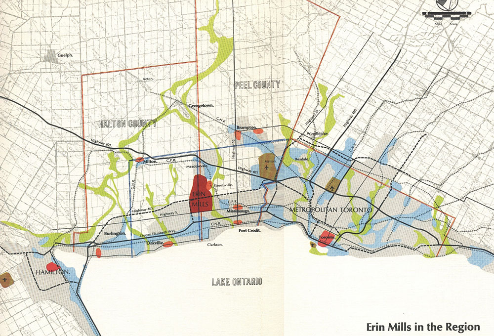
Fig. 1 The Plan for Erin Mills in the Toronto Centred Region
From Erin Mills New Town, 1969, Don Mills Developments
Erin Mills was designed to be far enough from Toronto’s growth that it could establish itself as a new community with some autonomy. Note how Erin Mills’ land assembly is in a central location between the cities of Toronto and Hamilton, and is located close to the Toronto region’s international airport. North Pickering would have been on the eastern edge of the map, almost mirror imaged to Erin Mills in relation to Toronto, and with its own airport. This plan is the origin of the GTA metropolitan area as its own creature.
Fig. 2 The Erin Mills Plan of 1969
From Erin Mills New Town, 1969, Don Mills Developments
The city plan of 170,000 for Erin Mills was comprised of an interconnected network of “Don Mills” style suburban communities of approximately 20,000 to 30,000 inhabitants each. The arterial road grid which connected them all was adapted from the historical Ontario agricultural road grid, and combined with the community roads on which the local Erin Mills centres were located. These were formed by a type of “tartan” collector road grid offset from the arterial grid, and which provided evenly spaced centralized locations for the higher urban residential densities, retail plazas, and community buildings.
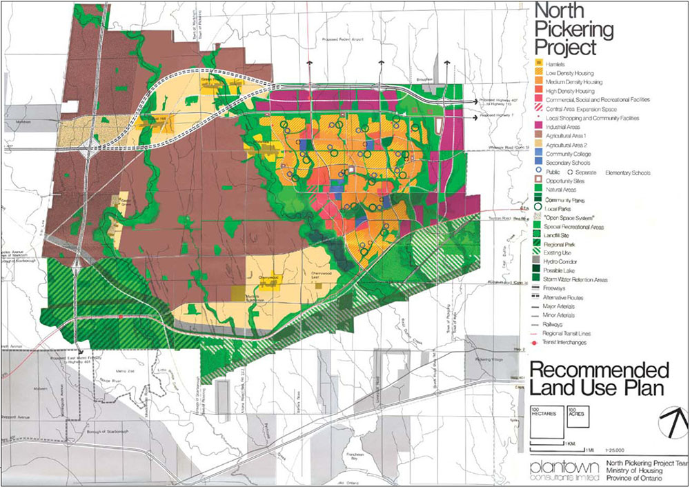
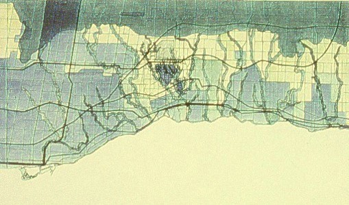
Fig. 3 The Pickering North Plan of 1975
From Central Pickering Development Plan, 2006
This plan was almost as large as Erin Mills but proposed five years later. Note the agricultural land preserve already in effect to the south-west of the land assembly. The airport lands are to the north, off the map. The large green corridors on the south edge of the urban plan follow the old Iroquois glacial lake shoreline and are a combination of infrastructure corridors, aggregate quarries, and green parkland reserves.
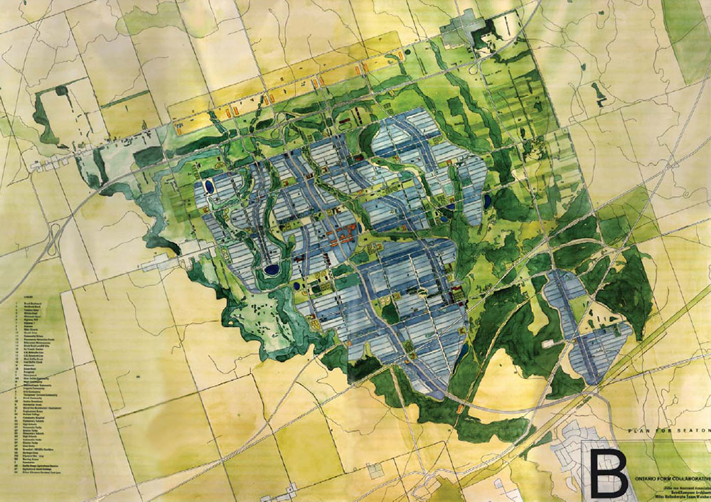
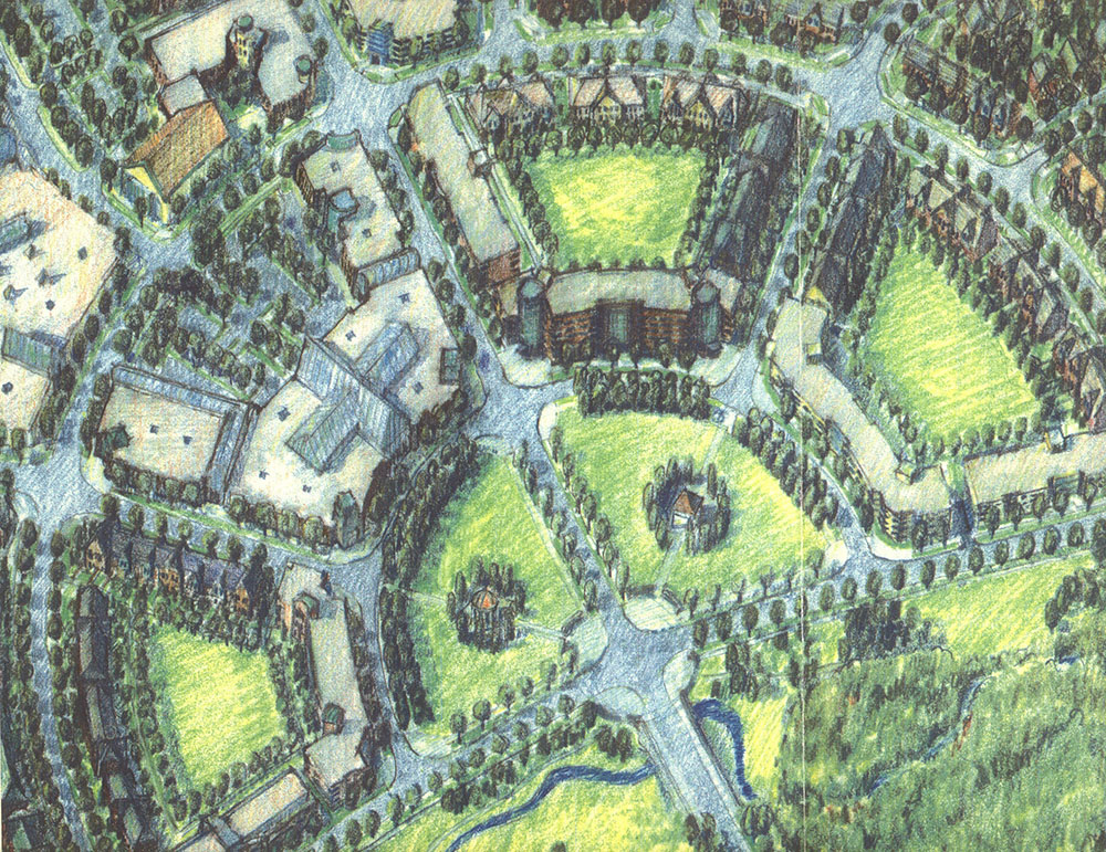
Fig. 4 The 1994 Seaton Plan Competition Winner
Author’s personal digital files
The 1994 Seaton plan has three main formal features. The first is a green infrastructure system of creek restoration and new east-west cross corridors. The second is a town centre located on a central boulevard. An east-west block system was the third formal feature proposed to allow for easier passive solar siting for individual homes.
Personal
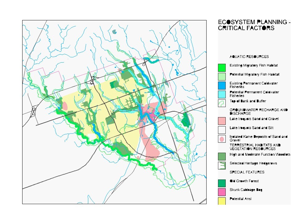
Fig. 5 Seaton 94, Critical Ecosystems Factors
Author’s personal digital files
This map combines a series of GIS layers to create a view of the critical ecosystem issues for which any plan for Seaton would have to develop solutions. Of note are the broken fragmented stream corridors and the large amount of land at the Lake Iroquois shoreline that is a major groundwater recharge zone.
Fig. 6 Seaton 94, Ecosystem Rehabilitation
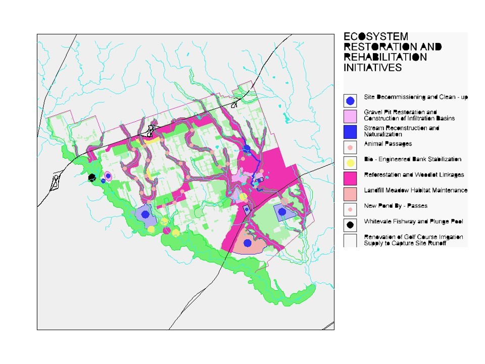
Author’s personal digital files
This map layer outlined the rehabilitation efforts for existing ecosystems and for new reforestation of creek corridors and the new cross corridors running east-west. This is also combined and integrated with cleanup and rehabilitation of the major groundwater recharge zones to the south of the urban area.
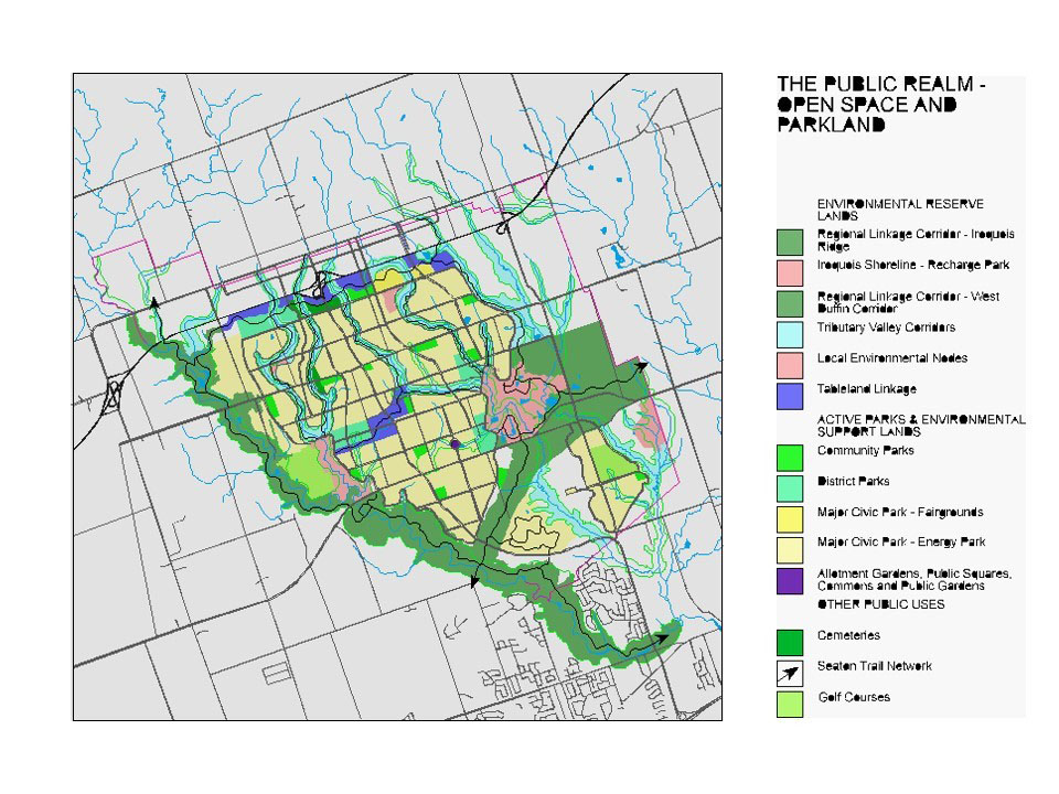
Fig. 7 Seaton 94 Open Space and Active Recreation
Author’s personal digital files
This map layer combines the Ecosystem Rehabilitation layer with the active park layer to outline the complete green infrastructure system. The active parks found in any community are a useful land use to complete naturalized corridors. Despite their daily use as recreational open space, with appropriate design they can, also act as naturalized ecosystem corridors.
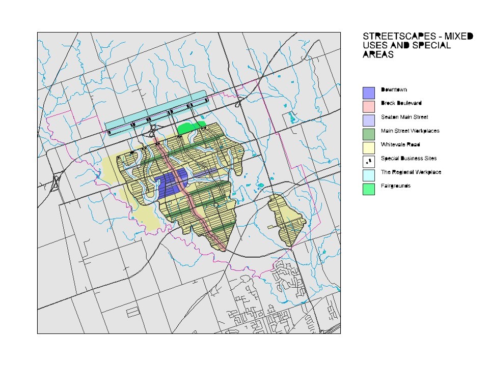
Fig. 8 Seaton 94 Transportation Infrastructure
Author’s personal digital files
The road and transportation infrastructure networks for the plan are relatively conventional with a central arterial boulevard much like Erin Mills Parkway, exiting from the future 407 expressway, and passing through the new town centre. Running at regular intervals off the parkway are what the plan calls workshop collector streets combining mixed functions. There is an extensive transit network but it is at a relatively conceptual stage of planning.
Fig. 9 Seaton 94 Developed Urban Areas
Author’s personal digital files
The urbanized area of Seaton is set in the lands between the re-naturalized urban creeks. These are transected by the workshop collector streets which are intended as multi-use main streets of higher residential density and work places. The central main street running through the downtown, where it intersects the central parkway/boulevard is the location of Durham College.
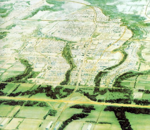
Fig. 10 Aerial View of Seaton 94
Canadian Architect, March 1995, Vol. 40, no. 3, cover image
The view is of Seaton from the north across the 407 expressway. The creek corridors are shown re-naturalized and the residential areas are set between them.
Fig.11 Seaton 94 in the Region
A Plan Seaton for Seaton, Ontario Form Collaborative, 1994
The future new town is set inside the GTA fabric and crisscrossed with the region’s transportation and power infrastructures. As well, it’s clear that the urban creeks run continuously across the GTA as a set of green corridors from the Oak Ridges Moraine in the north, to the Lake Ontario shore in the south.
Fig. 12 Land Assignments up to 2002
Author’s personal digital files
After the 1994 plan was shelved, the land assembly was re-assigned to three distinct zones, the Rouge Valley Park, the agricultural preserve, and the still dormant Seaton urban site.
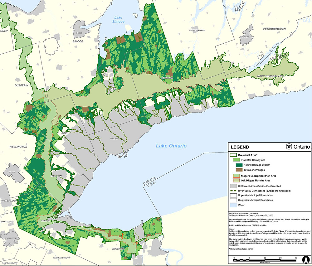
Fig. 13 Ontario Greenbelt Natural Heritage System
From Ontario Greenbelt Plan, http://www.mah.gov.on.ca/Page189.aspx
The Ontario Greenbelt of 2005 was built on two major natural area already in existence as protected area, the Oak Ridges Moraine and the Niagara Escarpment. It widened each zone and created a protected landscape of natural areas and agricultural countryside (with towns and hamlets). The existing urban aras were maintained as well as a set of “white lands” where future urban growth could occur within guidelines that encouraged more intensive land development.
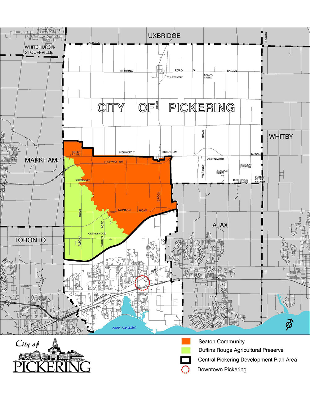
Fig. 14 Town of Pickering, 2006
From Central Pickering Development Plan, 2006
This map is for reference to show the exact location of the agricultural preserve and the Seaton lands within the urban boundary, of the Town of Pickering.
Fig. 15 Pickering Plan pre -2001
Town of Pickering web site, early 2005
The pre-2001 plan for the area developed by the Town of Pickering showed a very conventional land use arrangement of the type found anywhere in the GTA.
Fig. 16 Pickering Plan, 2003
Town of Pickering web site, early 2005
The 2003 Pickering plan completely accepted the natural systems corridors of the 1994 plan but extended them onto the agricultural preserve as it allowed residential development there as well.
Fig. 17 Greater Golden Horseshoe, 2008
Places to Grow, https://www.placestogrow.ca/index.php
The Greater Golden Horseshoe showing the Ontario Greenbelt as a type of green armature linking a very broad region of cities, towns and rural communities.
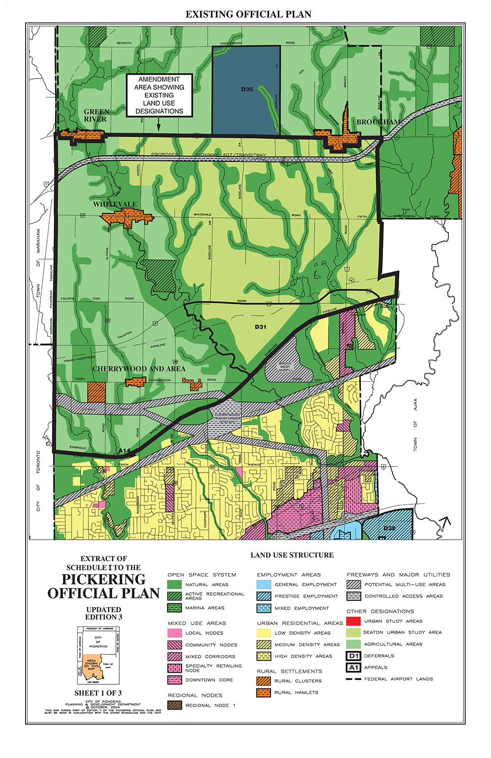
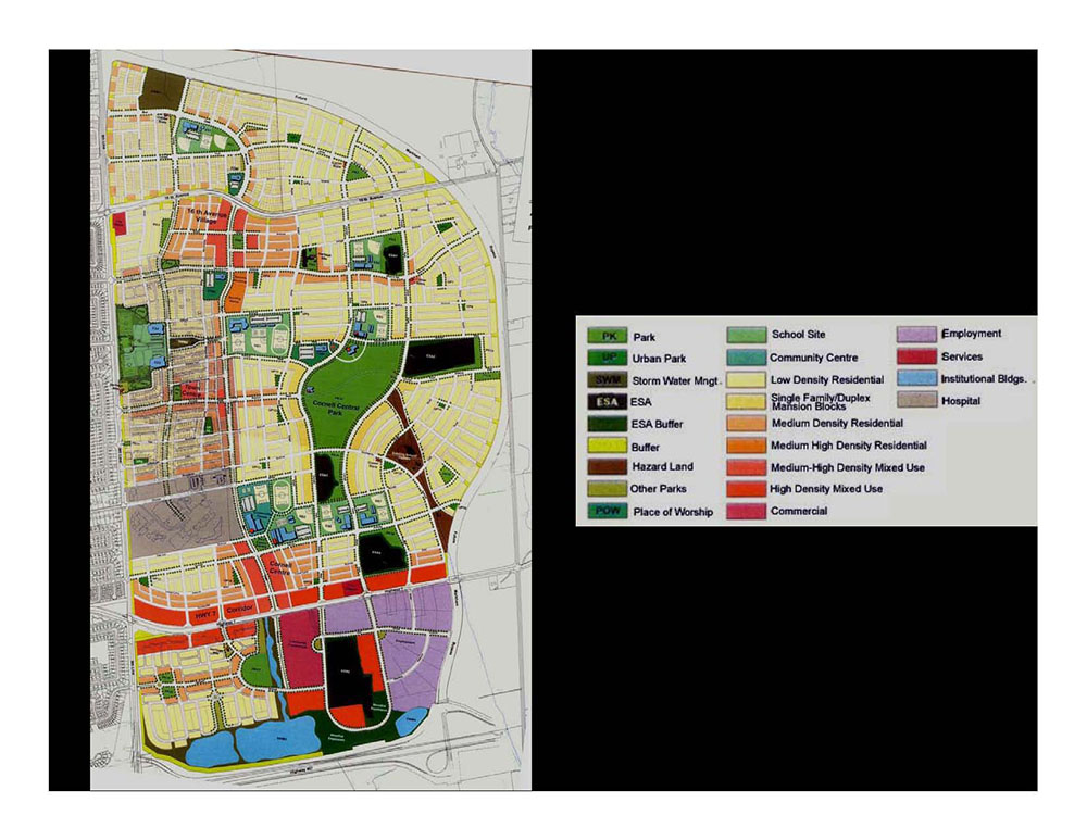
Fig. 18 Central Pickering Land Use, 2006 CPDP
From Central Pickering Development Plan, 2006
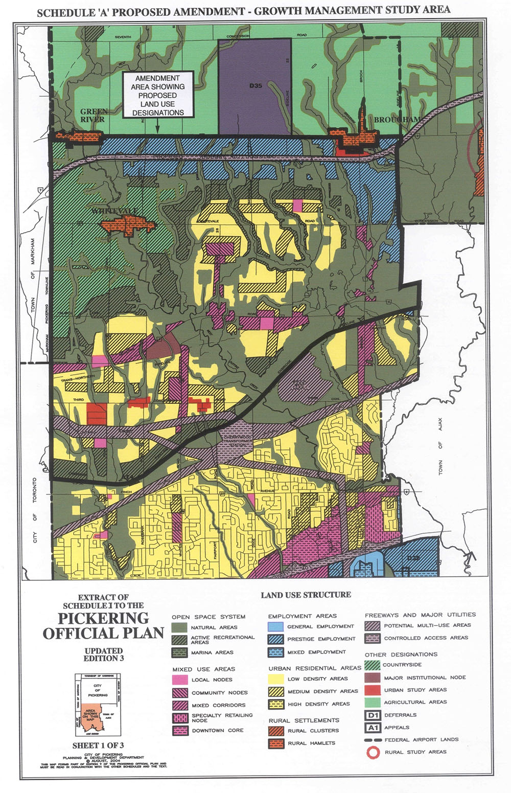
In the 2006 Central Pickering Development Plan (CPDP), the 1994 plan has been modified to become more integrated with the metropolitan field of the GTA. All centralizing aspects of the new town have been removed, the central boulevard replaced with a network of arterial roads integrated with the bigger grid of the GTA, the town centre has been decreased in size and much of its density and commercial uses redistributed to the Taunton Road arterial. The industrial/office sites now frame both sides of the 407 expressway. The only system left intact from the 1994 scheme is the natural heritage system with its rehabilitated creek waterways and the east-west naturalized park cross corridors. There is also a strong reassertion of the integrity of the agricultural preserve to the west.
Fig. 19 Central Pickering Natural Heritage Systems, 2006 CPDP
From Central Pickering Development Plan, 2006
As noted, this is the one system in the 2006 CPD Plan that remains unchanged from the 1994 Seaton competition winner.
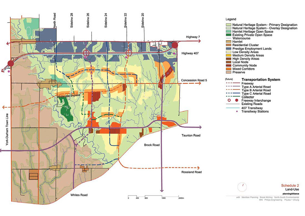
Fig. 20 Central Pickering Transportation Infrastructure, 2006 CPDP
From Central Pickering Development Plan, 2006
This map shows the complete integration of the Seaton transportation system with the GTA network as the new town concept disappears. The GTA network is still largely an Erin Mills style system in which the arterial road grid is still overlaid on to the 19th century agricultural grid.
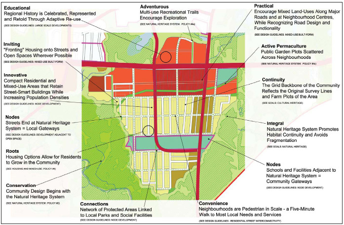
Fig. 21 Seaton Neighbourhood Urban Design, 2006 CPDP
From Central Pickering Development Plan, 2006
There is nothing really innovative about Seaton neighbourhood design beyond that of 1990s New Urbanism re-thinking of suburban street systems.
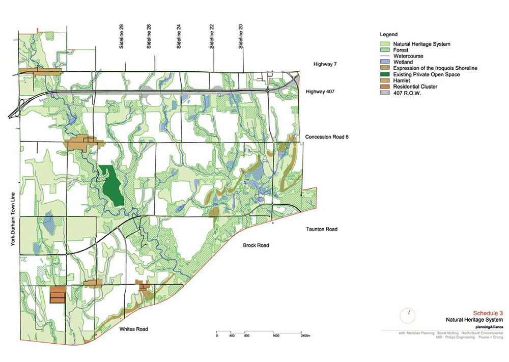
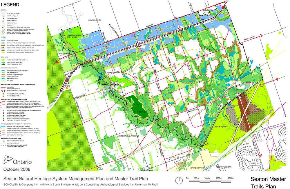
Fig. 22 Seaton Natural Heritage System 2008
From Town of Pickering web site
More than the Figure 18 Natural Systems layer, the latest 2008 plan shows the detailed information that can be built into a GIS based planning system.
Fig. 23 Places to Grow Concept Plan, 2006
Places to Grow, https://www.placestogrow.ca/index.php
Southern Ontario developed as a layered set of initiatives combining strong underlying natural ecosystems, a high quality of interlinked road and transit infrastructures, intensified urban development in existing areas, and a strengthening of existing urban centres.
Fig. 24 Cornell original Duany Plater Zyberk plan
From http://www.publicspaceworkshop.ca/public_engagement.html
The second version of the DPZ plan which was presented to the municipality. Already there is the beginning of a concentration of commercial development at the intersection of the Cornell high street and Highway 7. The high street is still the main spine of Cornell.
Fig. 25 Fletcher's Meadow Plan
Developed by the author for the MBTW office in 1991.
The project is on the edge of the northwest periphery of the City of Brampton in the 1991 GTA. There are two central areas for the town, the bigger one in the actual geographic centre, and a smaller one at a GO commuter train station in the south west of the plan. The building of the station was delayed until a decade ago and that centre until the last two years.
Fig. 26 Fletcher's Meadow View of Centre
Developed by the author for the MBTW office in 1991.
The centre was never built and the shops and, much like in Cornell, apartments of the central site were slowly accreted to the edge of Highway 7 at the bottom of the plan. Only in the last year are apartments now being considered for the GO railway centre along with the retail uses.
Fig. 27 Cornell revised by Markham 1993
From the Town of Markham web site in 2003. The drawing is no longer available.
After a decade the original plan by DPZ was barely recognizable after it had been adapted to the conventional practices of the Erin Mills planning system. Note the large amount of retail along the highway arterial, the lack of a high street and the new business park south of the highway.
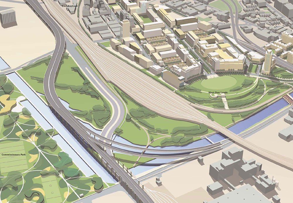
Fig. 28 Toronto Don Lands Flood Barrier Park
West Don Lands Precinct Plan, 2005, developed for Toronto Waterfront Revitalization Corporation by Urban Design Associates, Joe Lobko, Architect, and du Toit Allsopp Hillier
The West Don Lands is a relatively conventional urban design project with an extensive naturalized landscape urbanism style park along the Don River. The park though developed with natural riparian ecosystems also acts as an engineered flood barrier between the river and the new urban precinct. The landscape also incorporates a pre-existing railroad embankment for one of Toronto’s main rail arteries to the east. Much of the other redevelopment work to the south of this precinct also shares these three characteristics of urbanism, major infrastructure, and natural river landscape.
Author’s Biography
Val Rynnimeri is an Associate Professor at the School of Architecture at the University of Waterloo where he teaches architectural design, urban theory and design, ecosystem design of urban landscapes, and cultural history. Before he joined the School, Val worked in a wide range of professional practices in Toronto, New York City, Guelph, and Waterloo doing architecture, urban design, landscape design, and urban and environmental planning. He was one of the key designers for the MBTW Group on both of the competition winning projects for Toronto’s Cloud Garden Park and the Seaton New Town in the Pickering area of the Greater Toronto Area (GTA). At the School of Architecture Val has been a central participant in the university based project partnership for the Auschwitz-Birkenau Master Strategy, and the main design coordinator the Master Plan for Kitchener’s Huron Natural Area ecology park. Val also has a graduate degree in History and is engaged in writing about the history of the GTA urban periphery.

EWT/ EcoWebTown n.7
Magazine of Sustainable Design
(Quadrimestrale on line sul progetto di città sostenibile)
Edizione SCUT, Università Chieti-Pescara
Registrazione al tribunale di Pescara n. 9/2011 del 07/04/2011