Trentino Alto Adige. Una regione sostenibile a cura di Pino Scaglione, Chiara Rizzi, Stefania Staniscia con Edoardo Zanchini
torna suOne, None and a hundred thousand “Northeast cities”: infrastructure and scenarios. Laura Cipriani* 
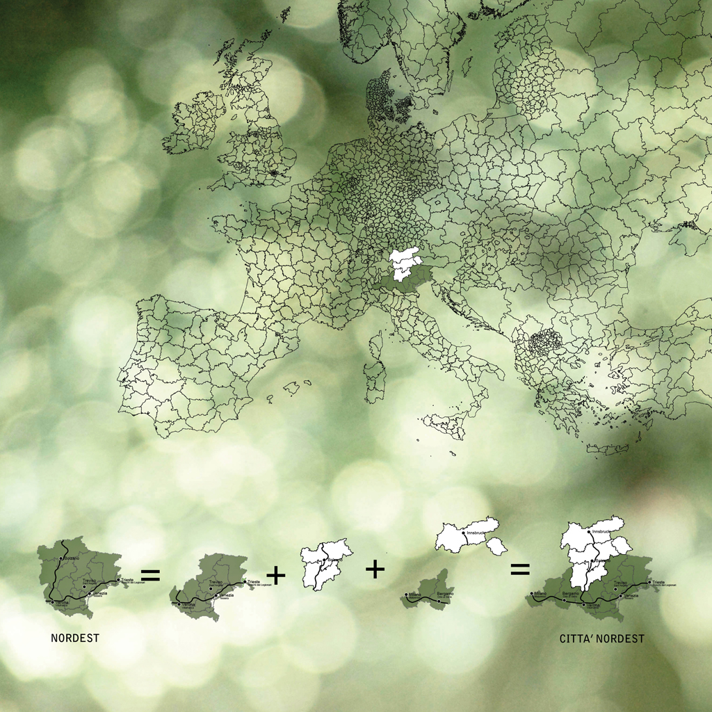
We speak a lot about “Northeast city”. Though officially unrecognised and not formalised on the map, it is one of Europe’s most important macro-regions. With more than 7 million inhabitants, an overall GDP equal to that of the Czech Republic and covering an area as large as Switzerland, “Northeast city” includes the Veneto, Friuli, Trentino-Alto Adige and even extends beyond Italy’s borders.
In fact, the renewed imagination of this macro-city was born not only from a re-evocation of distant historical realities or from the unquestionable geographic contingencies, but rather it is the fruit of an implicit design based on its infrastructure, their use and the awareness that the competitive systems of the future will be those interconnected by an intelligent metropolitan organisation. The crisis of the entrepreneurial system spread throughout the northeast favours the conviction that the network, or better, the networking of the infrastructure – physical, but also technological – is the key to connecting territories, competences and above all economies.
Mobility has always determined the form of the city and of the social relationships that take place within it. Space, time and economic activity are the relevant variables that depend directly on mobility. Simplifying we might state that the design of pre-modern urban spaces – the ancient polis, the ancient villages, Greek, Roman and medieval cities – are nothing but a corporeal translation of the act of walking, i.e. the equivalent to an environment articulated into 2.5-kilometre radii. The same can be said of the metropolitan areas of the industrial revolution which developed according to train speeds, of the cities that developed as a function of private cars or post-automobile globalization cities which, with the advent of air transportation, now extend to areas with radii of 500 kilometres, or the distance a plane can fly in an hour.
The current mobility projects in the Northeast only make sense from a macro-scalar point of view, but what in reality is the Northeast city? Where are its boundaries? How many Northeasts can we draw or imagine?
Mobility in the Northeast is, in itself, a kaleidoscope. It changes according to perspective we adopt and the type of mobility to which we are referring. There is the Northeast motorway which corresponds to the A4 and A22 systems (motorscape); a fragmentary rapid transit of the Northeast which is in full ferment partly dependent on current and partly on rail lines still to be built (metroscape); a Northeast aviopolis composed of a multiplicity of airport structures of differing levels which is yet to be organised (airscape); and finally, to this infrastructure net of asphalt, steel and air, one may also add the landscape of aquatic mobility which includes the many river basins – Adige, Brenta-Bacchiglione, Piave, Scolante basin, Livenza, Lemene, Tagliament, the Marano and Grado lagoon, Isonzo, Slizza and Levante – which for many centuries were one of the main mobility systems (waterscape).
Though Northeast city is crossed by the important Communitary corridors V and I, making this area one of the hubs of the wider scenario of European mobility, there is still no comprehensive vision. Northeast city is organised around fragmentary infrastructure networks mostly based on road mobility and only secondarily on rail. There are two recognisable Northeasts: on the one hand, the infrastructure on the plain, organised mainly around along the A4 motorway; on the other, the Alpine system which winds along the A22 motorway and extends beyond the Italian border. Choosing to divide it up in this way – though rather arbitrary – is recognition both that the areas depending on the relative metropolitan centres are closely related to the infrastructure of the road systems and in part that of the railways as well as the physical geography of the territory, the one a plain and the other Alpine are radically different and as such require specific attention.
Northeast Metro
In recent years Trentino has become a leader in renovating the concept of mobility.
The prevailing motorized monoculture of the Alpine regions is quite intense but much of this is traffic crossing a border. As the scarcity of the available space in the valleys has meant it is hotly competed for by agriculture, infrastructure and cities. The Province has pursued a policy aiming at a rethinking of the transport system.
The general theme is “sustainable mobility”, promoted in the first place by the Alpine Convention to integrate commuter demand with tourist demand. The Metroland project in Trentino province was born in this context, a rail structure which many characteristics of a rapid transit system that will supply fast transportation between the heart of the Trentino region and its widely separated urban areas. The intention is to join the valleys separated by the Adige with fast connections, a technological connector to counterbalance the slow mobility imposed by the morphological laws of the landscape.
The four main lines planned for the project (Trento-Malè, Trento-Tione, Trento-Songa and Trento-Primiero) converge on the provincial capital, making Trento an important centralising hub of services and competences. As 170 kilometres of the 200 total would be through tunnels, quite a number of environmental and economic questions have been raised by the project, but the revolutionary idea resides in the vision, in imagining Trentino like a large metropolitan area where interconnection allows one to get out of the isolation imposed by the structure of the territory.
Using this as a point of departure, Northeast city is starting to rethink old mobility methods in a contemporary key. In the Veneto the project for a rapid transit rail service among the several metropolitan areas – regional railway system – was first mooted in the 1990s to harmonize growing road traffic with that on rail, but it was not until today, with the crisis and with the Trentino proposal, that it was put back on the front burner.
In Friuli-Venezia Giulia the light metro called “Adria _A”, reuses in part existing rail structures and should manage to connect Trieste, Capodistria and Sezana, Gorizia and Nova Gorica, crossing the border toward the east.
So what will the scenario look like in the Northeast in 2050 or 2100? Can innovations, or on the contrary and above all technological (d)evolutions, be the stimuli for a rethinking of mobility systems and for the creation of new landscapes?
* The researcher has received support from the EU and the Autonomous Province of Trento in an action co-funded by Marie Curie Actions. The work presented in this publication benefited from funding by European Union 7 PQ/2007-2013 and the Autonomous Province of Trento with grant No. 226070 (in the competition “researcher post-doc 2010 incoming CALL 1” for the project “Trentino – PCOFUND-GA-2008-226070”).

EWT/ EcoWebTown n.4
Magazine of Sustainable Design
(Quadrimestrale on line sul progetto di città sostenibile)
Edizione SCUT, Università Chieti-Pescara
Registrazione al tribunale di Pescara n. 9/2011 del 07/04/2011