Trentino Alto Adige. Una regione sostenibile a cura di Pino Scaglione, Chiara Rizzi, Stefania Staniscia con Edoardo Zanchini
torna suA22 @BZ Bolzano, the motorway and the plan of their possible futures. Thomas Demetz 
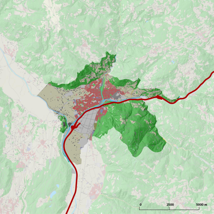
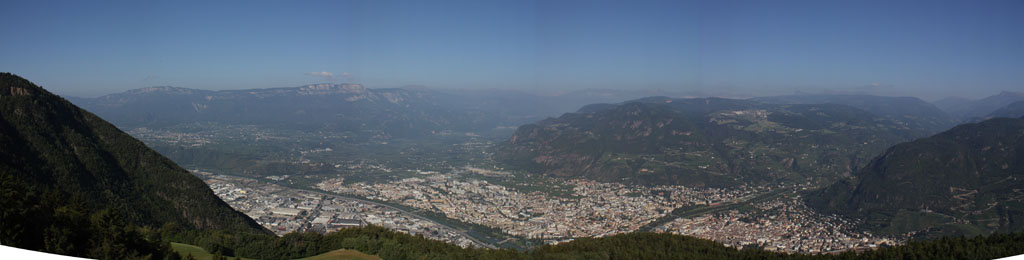
The character of the relationship between Bolzano and the Brenner Motorway has several degrees of complexity that transcend the purely functional aspects linked to the latter’s role and impact as a continuous infrastructure system. The characteristics of the context emerge from a modulation of the factors that go from the geomorphologic characteristics of Bolzano’s valley, from the presence of a branching river system with intensely reinforced banks to the articulation of the vegetation and the ways the city is used. Bolzano, as a city is characterised, to use one of Silvano Bassetti’s (1) favourite expressions, by a regime with a scarcity of soil. The municipality is located at the confluence of three different valleys of which two, the Isarco Valley and the Adige Valley, are of an Alpine significance. It goes from 230 to 1600 metres above sea level and covers 52.34 square kilometres, 49% of the territory below 300 metres runs right to the base of crowning heights which form two-thirds of the city’s horizon. The settled areas occupy about 30% of the total and are mostly found under the 300 metre level while the rest of the valley floor is used for agricultural purposes, mostly high yield, as well as accommodating the three river beds that flow to join and become the Adige.
These several functions are densely packed and fill the Bolzano basin till they rest against the walls of encircling mountains. When the course of the Brenner motorway route was defined in the 1960s the only reasonable route was along the eastern bank of the Isarco River and the use of tunnels was excluded as the confirmation of the territory would have required that they be long, expensive and difficult to guarantee from a safety point of view. The route along the river bank, at the time totally uncultivated, constituted a morphological support that wound through that system of uses and functions of its terrain without encountering particularly conflictual conditions, except the Virgolo hill, a spur of rock reaches right down from Monte del Colle to the bank of the river. However, this route was crossed by the several axes crossing the Irasco, a series of bridges starting with the historic bridge toward Asiago, the part of the city contained in the southern hollow of the arc formed by the heights starting with the Virgolo and then toward the south the bridges that connected the residential city to the industrial one which was constructed following the urbanization policies and forced industrialization introduced under Fascism. The solution adopted was that of building an urban viaduct, a raised roadway along what had for ages been “no-man’s” land, a land expelled from everyday life and populated by exclusion, as for example a spontaneous gypsy camp. The perception that one had from the residential part of the city, that on the west bank of the Isarco was partial because it was in large part hidden by stratified strips: bankside vegetation, the base of an unused rail line whose traffic was relocated on the Bolzano-Merano line, residual spaces squeezed between the settlement areas and the heterotopy of the river banks. The sequence of territorial elements has produced a sort of composite segmentation, perceptibly impermeable and perceptibly absent, with the river as its the backbone and the raised motorway was only one of the several layers that, drowned in this bundle, was mitigated in its possible impacts, and as part of a system that was outside the notion of everyday it too was just excluded.
Starting in the 1970s, the paradigm of the river changes progressively. Earlier the river system was interpreted in primarily hydraulic terms, a producer of risks and generator of territorial and urban caesurae. In the case of Bolzano, it is progressively recognised as a space into which the city can expand, mainly for recreation. But the most important change was produced by the recovery of part of the floodplain of the Talvera, the third river of the Bolzano basin. This was recognition of the fact that hydraulic systems in urban areas can become an ordering rather than limiting element. The uncontrollable, potentially chaotic, eco-systemic infrastructure enters the design of the city and transforms the floodplain of this Alpine stream with its dense meanders into a public park, changing the heterotopic of the river into what soon became one of the city’s identifying factors.
At the same time the void that existed between the raised motorway and the strongly artificial riverbank below it was becoming increasing obvious. Bernhard Winkler’s 1990 urban plan for Bolzano’s mobility introduced a system to distribute vehicles in a comb-like pattern: the crossing road system axes are removed from the city and set in what was fundamentally a marginal area, however, transforming it from a residual marginality into a functionalized marginality and, all considered, the costs in terms of land were limited. The intervention to which the riverbanks had already been subjected had been significant and the new bankside road curls along a line dictated by the several existing bridgeheads.
It was with the elaboration of Bolzano’s master plan, starting in the middle of the last decade, that the theme of the relationship between the city and the motorway came into discussion. For the municipal administration the master plan was to be the tool that would define the framework for the city’s development strategies to supplement the provincial level urban plan with one capable of distinguishing between structural and operative levels. The only instrument in the Municipal Urban Plan (PUC), sanctioned by the current Provincial Urban Law, much of it referable to the so-called second generation of urban planning, was mono-functional zoning codes over time loaded with more and more modifications, some hyper-regulative and some derogating, until it finally lost the levels of excellence which the tool had obtained in facing the prerequisite mechanisms and procedures for urban interventions capable of overcoming most of the impasse that national urban planning norms had suffered from between the 1960s and 70s, at least until the modification of Article V of the Constitution and the consequent introduction of regional urban planning laws.
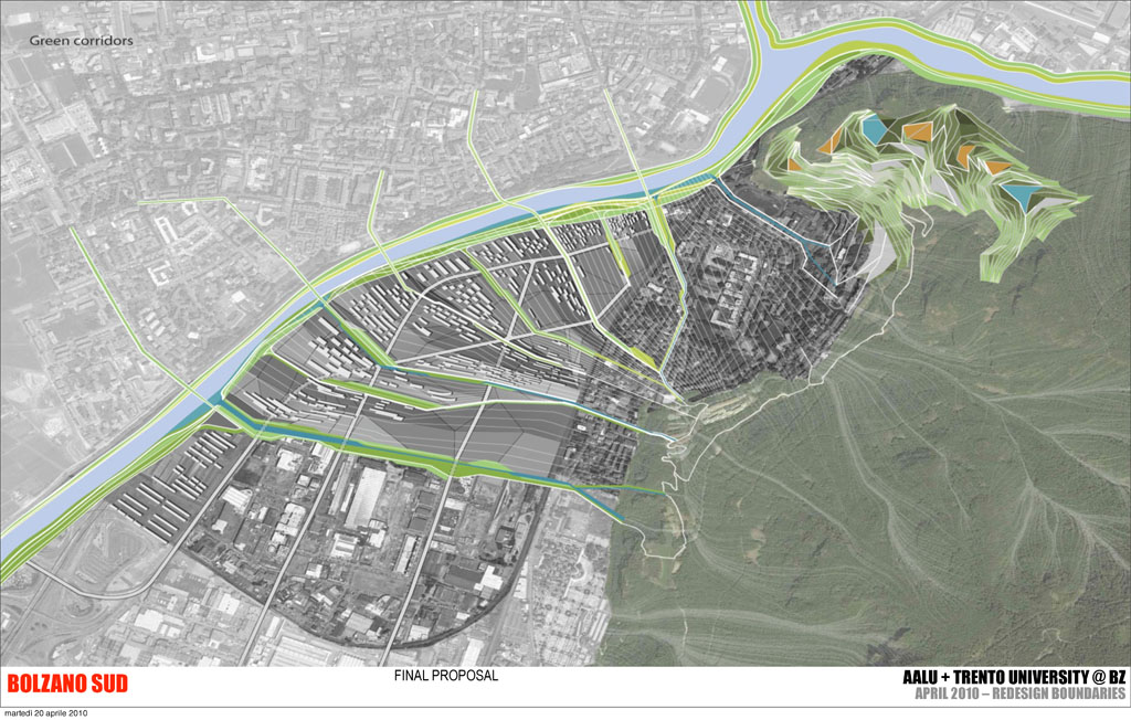
The declared intention of the master plan was to rejoin the several parts of the city more effectively and it attributed to the raised motorway a particular separating role in the urban fabric, above all, as it lay along one of the internal margins and emerged significantly as compared to the several layers of the city and because in the meantime also the west bank of the Isarco had been reacquired, the one overlooking the area occupied by the motorway and which becomes the main backdrop together with the width of the retaining walls of the bank. The plan calls for an alternative route for the urban section of the A22 and this almost certainly had to be in a tunnel. The reconfiguration of the urban stretch of the A22 raises numerous questions and generates as many opportunities. The questions essentially concern the possible transferal of the location: the mountains dominating the east side of the city and in part already housing a number of road tunnels, bypasses of towns to the south of the city and destined to host the rail bypass, as well, which was agreed to by the provincial administration and the national railways and was in planning, a bypass that was part of the access system to the southern entrance to the planned tunnel at the base of the Brenner Pass for commercial traffic.
The demission of the existent raised motorway would allow the achieving of two goals: the expulsion from the urban area of a source of pollution, measurements at the motorway intersections by the provincial health agency had recorded the highest levels of benzenes and particulate matter, because of the added effects of different infrastructure. The second goal was to knock down an important barrier to the landscape, which had even been raised in height when anti-noise systems were put in place.
The opportunity that this type of action offers is in part one of visioning over the city and in part recognisable in analogous processes. The master plan puts among its objectives the reconversion of the north end of the industrial zone of Bolzano, an area now composed of small warehouses, some abandoned, for operations made commercially difficult if conducted in a place that is marked and perceived as an anywhere else. Some even mentioned the possibility of extending the “riverside park”, which was becoming increasing one of the city’s identifying elements, along much more of the city’s fluvial system, with pavilions, and sports and cultural venues. Little is said about the viaduct, except the indication of a possible demolition and a boxing-up of the riverbank road. Attempts made to imagine possible transformations were carried out in the urban planning laboratory of the undergraduate school construction engineering and architecture at the University of Trento and during a workshop held in Bolzano in 2009 in collaboration with an AA master programme in landscape urbanism by the Universities of Trento and Innsbruck. The results that emerged from these two different experiences were several and contradictory. The projects elaborated during the urban planning laboratory looked at the theme proposed, that of the possible reuse of the abandoned infrastructure and of the connections among the several levels. Influenced by the High Line project in New York they sought solutions that involved the total reuse of the motorway, while the AA workshop showed that the barrier effect was due solely to the perceptive dimension and the requirements that were really necessary to reconfigure the infrastructure were absent. A careful design of the vegetation spaces and the use of appropriate species might however allow one to reach the objectives set up by the master plan. Coherently with the outcome of the workshop, it was the railway just to the east of the motorway which was the much more effective and much more difficult barrier to move toward a more favourable arrangement and a rejoining of the several identified bits of the city. This runs through the Asiago-Oltreisarco neighbourhood on a level which was only slightly higher than that of the surrounding countryside, forcing transversal roads into deep underpasses and producing a series of unresolved residual spaces posing a much more complex challenge of the urban disequilibria in Bolzano.
The transformation of master plan into an administrative document has in part diluted the strongly experimental character that it had at beginning and it seems that it has renounced trying to endow itself with an automatic mechanism capable of maintaining the high level of research on the possible futures of the city. This, at least, would have been coherent with the spirit of Silvano Bassetti who promoted and supported this instrument.
Bibliography:
Atlas, Review of the Istituto Nazionale dell’Urbanistica dell’Alto Adige, No. 36 “Pianificazione del Traffico a Bolzano”, 2010.
http://www.gemeinde.bozen.it/UploadDocs/9163_Atlas_36.pdf
Municipality of Bolzano, “Masterplan”, 2009,
http://www.comune.bolzano.it/urb_context02.jsp?ID_LINK=3543&area=75
Sources for data:
Urban plan of the Municipality of Bolzano, 2012
ASTAT, Autonomous Province of Bolzano, 2011
Elaboration by the author
(1) Silvano Bassetti (Cavedago 12/12/1944 – Bolzano 26/4/2008), architect, assessor for urban planning for the Municipality of Bolzano from 2000 to 2008. In this role he made Bolzano a laboratory for experimenting urban praxis: OHA with Avventura Urbana; 4 Scenarios with Metrogramma, Ferroplan concluded with the competition to redesign the railway yard.
EWT/ EcoWebTown n.4
Magazine of Sustainable Design
(Quadrimestrale on line sul progetto di città sostenibile)
Edizione SCUT, Università Chieti-Pescara
Registrazione al tribunale di Pescara n. 9/2011 del 07/04/2011