
USA:
Toronto. Infrastructure and landscape for a new urban ecology. Jeanette Sordi * |
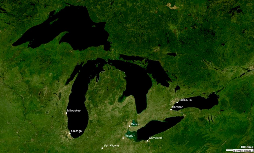
Toronto is located on the northwest coast of Lake Ontario, the easternmost of the Great Lakes. The city of Toronto, together with Chicago, Detroit, Cleveland and Hamilton, was one of the most important centers of the “Manufacturing Belt”. In fact, the area which surrounded the Great Lakes was dubbed with this sobriquet for its role in transforming raw materials and industrial production which, in the 19th century, drove the United States to expand toward the west. For about a century the region attracted millions of immigrants from Europe and the southern United States, catalyzed capital and dominated domestic and foreign markets (Ford and General Motors are only the two best known). The peak in productivity and wealth of the region was reached during WWII, but a few years later, the opening of global markets and the removal of duties on imported goods, determined its fate. Car production, metalworking and chemical industries moved to south-east Asia. In just a few years the “Manufacturing Belt” had become the “Rust Belt”1.
Because of the decentralization of productive activity this region used up its economic resources and passed through a period with high unemployment. In the 1970s investors and workers abandoned the industrial cities which caused such a loss of fiscal receipts that it became almost impossible to maintain the urban infrastructure, with serious consequences on a social level. With the economic crisis the environmental consequences of decades of intense industrial production began to emerge as well. These effects were not considered during the boom years of economic expansion. The fires on the intensely polluted rivers of Cleveland, Toronto and Chicago, the algae blooms causing eutrophication on Lake Eire and Lake Ontario and the mercury contamination in Lake Superior, Lake Michigan and Lake Huron, clearly showed the state of emergency in which the region found itself, and captured the attention of environmentalists (Bélanger, 2010a).
In the 1980s it was evident that the processes that had brought about the economic decline of the region were irreversible and that the time had come to face the environmental and social consequences of decades of heavy industrialization. At the end of the decade the United States and Canada set up an International Commission to put in motion a massive cleanup program of the Great Lakes region. Among the problems confronting the Commission were those of water pollution caused by city and industrial waste discharges, flooding caused by the covering of the soil with asphalt and the droughts caused by the deviation of rivers. Tackling the gap between economy and ecology was the main objective of the regeneration policies (Bélanger, 2010a).
The only source of fresh water for Toronto and its metropolitan area containing 5.5 million inhabitants is Lake Ontario. The regional policies initiated by the Commission in the 1980s gave the city the possibility of redesigning the infrastructure it used to supply, purify and distribute water. In fact just like in a closed system, all the water needed for the metropolitan area’s life comes from Lake Ontario and once it has served its purpose is sent back to Lake Ontario. Re-establishing an ecological relationship between the city and the lake was necessary to guarantee the “survival” of both. Not only, the substantial funds supplied to the region to realize the new infrastructure, gave the municipality of Toronto the possibility to exploit the transformation areas to rethink its public spaces. Several landscape projects have been carried out to improve life quality of the inhabitants and at the same time communicate to the city and the world the city’s future, an economically, ecologically and socially sustainable future. In this sense Toronto represents one of the most important cases in which, citing Pierre Belanger2, Ecology becomes economy and infrastructure is to be understood as landscape. The recent landscape projects built along the waterfront by Field Operations, West 8 and Michael Van Valkenburg Associates – are the visible result of a convergence between regional and municipal politics and the overlapping between hydric infrastructure and landscape projects.
Regional and international policies to clean up the environment have allowed the city to find the necessary funds to redesign its infrastructure, but without the commitment of the municipality of Toronto, and of the associations linked to it, this would not have been sufficient to insure urban regeneration. In the large scale negotiations for each single development project, the city granted building volumes in exchange of land and funds for the creation and improvement of open spaces and public parks. In this way, the open spaces were the result of incremental interventions rather than the outcome of a single general plan, strategic, more flexible projects based on potential opportunities and the interests in development (Glover, 2001). Not only, ever since the competition for Trinity Square in 1983, the city has required that the designing of public spaces be assigned by architecture competitions with a professional jury and that the designing groups include architects, landscapers and artists (Martins, 2001). The most famous example of this urban development policy is surely the 1999 tender for Downsview Park. Even though the project was not built following the competition, both the tender drawn up by Detlef Martins and the projects of the finalists by OMA, Bruce Mau (the winner), Bernard Tschumi and Field Operations were fundamental in redefining the relations between urban planning, ecology and landscape.
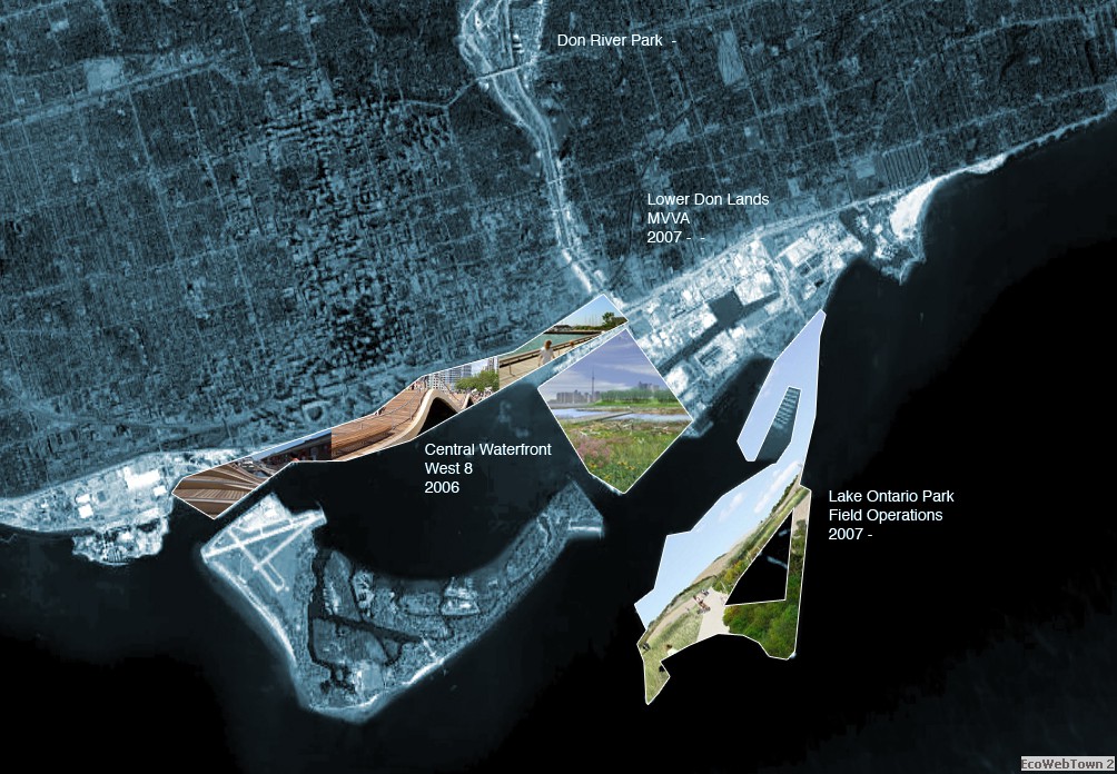
The development of the Toronto Waterfront began in 1980 when it was decided to recover the polluted areas of the port and create new hydric infrastructure that would clean and preserve the city’s only possible source of water: the Lake (fig. 1). Central Waterfront, Lower Don Lands and Lake Ontario Park are among the largest and the most interesting projects.
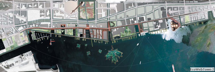
The Central Waterfront project coincides with the old port. Recently a new hydric system has been built in the area to filter and separate rain water from sewage and take them to a water treatment plant, also located in the waterfront area. The competition brief asked participants to create, through the landscape project, a new identity for the city while at the same time improving the efficiency of its hydric infrastructure. The winning project by West 8 (fig. 2, www.west8.nl, 2007-2011) defines a landscape that integrates the public space and the transport system on rails with an area to filter ran water connected by collection pipes. The floating wharves located in front of the walkways have a variety of public activities on their surface, while down below, at water level, there are support elements for the development of vegetation and seaweed as well as for the formation of wetlands. The wharves have been designed to improve the habitat of the fish and improve water quality by filtering polluting substances from it naturally.
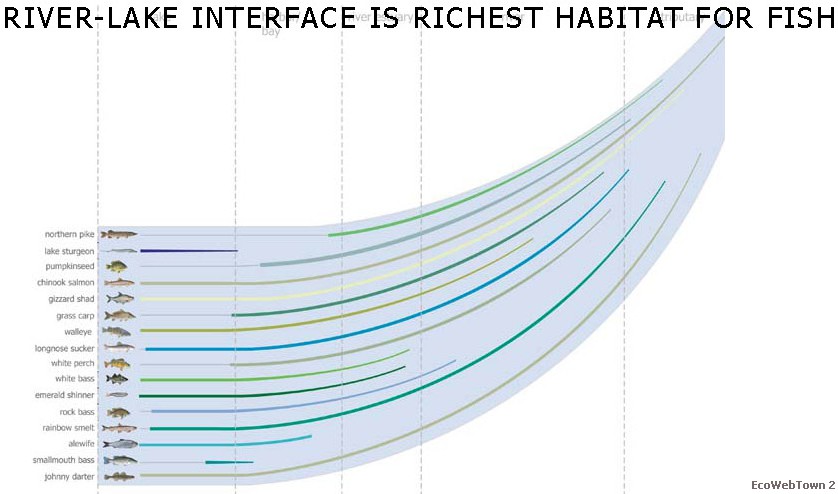
Also the project of Chris Reed-Stoss Landscape Urbanism, a finalist for the development of the Lower Don Lands at the mouth of the Don River, begins from water. In fact the priority of the project was to leave enough space so the riverbed could perform its hydrological and ecological functions (fig. 3, studies on the increase and reproduction of fish species in Lake Ontario, www.stoss.net). The river, on the other hand, as the origin of settled and open spaces modifies the metropolis. The winning project, developed by Michael Van Valkenburg Associates adopts a more urban approach, but also it gives great importance to water management. In the project area, 50% of the waste water will be recycled for irrigation and 100% of precipitated water will be used in Don River Park and Sherbourne Common for irrigation and other non-potable uses.
The project of James Corner-Field Operations for Lake Ontario Park (2007- ) is similar to that of Fresh Kills3. It is a combination of wetlands and dunes on degraded land. The new public recreation space and ecologic areas will be created adjacent to the water treatment and filtering plants of Central Island and Ashbridges Bay. The landscape and urban regeneration projects of Field Operations, West 8 and MVVA are the result on an urban scale of a systematic project of recovery and development on a regional scale. In fact in this way the cost of decontamination is borne by the development of productive areas on other sites. For the first time in the history of the Great Lakes, the common objective of an economy is based on cleanup and the use of fresh water has become a regional public priority (Bélanger, 2009).
The city of Toronto has regenerated itself by “recalibrating”4 its hydric infrastructure. In this sense, infrastructure can be understood as artificial ecologies that manage a site’s flows of energy and resources, creating the necessary conditions to respond to a continuous adjusting of the availability of resources, and modifying the quality of the settlements in response to changes in environmental conditions (Allen, 1999). The need to decontaminate the soil and purify the water has given Toronto the opportunity to rethink its public spaces and its overall image through an ecological and sustainable transformation.
As Pierre Bélanger has suggested (2009), economic decline can become the driver for an ecological regeneration. As catalytic infrastructure, landscape becomes visible in the very moment in which the city fails.
*Post-graduate researcher in the School of Architecture of the University of Genoa, Italy
Visiting PhD Candidate at Harvard Graduate School of Design, Cambridge, Massachusetts
1 This region was referred to as the “Rust Belt” starting in 1980s.
2 Pierre Bélanger, “Redefining Infrastructure”, Ecological Urbanism, Mohsen Mostafavi and Gareth Doherty eds. (Baden: Lars Müller Publishers, 2010) , 332-349
3 Fresh Kills is the project by Field Operations in 2001 to transform the landfill known by this name on Staten Island in New York. The project is ongoing.
4 Chris Reed’s course “Recalibrating Infrastructure” at Harvard Graduate School of Design, was for me the occasion to look in depth at the relationship between the development of infrastructure and the landscape projects of the city of Toronto.
Articles/Internet sites for reference:
Allen, Stan. 1999. Infrastructural urbanism. In Points + Lines: Diagrams and Projects for the City, 46–59. New York: Princeton Architectural Press.
Belanger, Pierre. 2009. “Landscape as Infrastructure” in Landscape Journal Vol. 28 Issue 1 (Spring/Summer 2009): 79-95.**
Bélanger, Pierre. 2010a. "Regionalization: Probing the Urban Future of the Great Lakes Region", JOLA Journal of Landscape Architecture, Fall 2010): 37-48.
Bélanger, Pierre, 2010b. “Redefining Infrastructure,” Ecological Urbanism Mohsen Mostafavi and Gareth Doherty eds. (Baden: Lars Müller Publishers, 2010), 332–349.
Glover, Robert. “City Making and the Making of Downsview Park”. Case: Downsview Park Toronto, Julia Czerniak ed. (Munich, London, New York: Prestel Verlag, 2001), 34-39
Martins, Detlef. “Downsview Park International Design Competition”. Case: Downsview Park Toronto, Julia Czerniak ed. (Munich, London, New York: Prestel Verlag, 2001), 24-31
http://www.waterfrontoronto.ca
http://www.toronto.ca/
http://www.fieldoperations.net/
http://www.mvvainc.com/
http://www.stoss.net/
http://www.west8.nl/

EWT/ EcoWebTown |