Designing a Metropolis. Rotterdam looks ahead
Marica Castigliano
A slow and careful look at Rotterdam is needed to understand the rapidity with which the city is changing. As the second city of the Netherlands, after Amsterdam, Rotterdam has decided to become a metropolis and started during its post-war rebuilding to create its identity as an innovative and multicultural European city.
The clarity with which Rotterdam’s development strategies have become concrete surprises though we infer it coherently from the projects used for its open spaces, the creation of new iconic volumes and the recovery of obsolete or abandoned structures and infrastructure. However, stylistically Rotterdam has been defined the least Dutch city of the country. Even though there are a few of the old houses with narrow facades, and the absence of a network of canals and characteristic small bridges in the urban fabric, Rotterdam fully embodies the virtues of efficient Dutch planning (Faludi & Valk, 1994) and the solid technical capabilities of a nation able to urbanise territories below sea-level, despite the constant threat of flooding.
The city grew up at the confluence of the Rotte and Nieuwe Maas Rivers and is crossed by a navigable canal that cuts the city in two and that, rather than only dividing the centre – historically located to the north of the river – it rips apart the urban fabric accentuating the discontinuity of the morphological plan and social fabric. To limit this difference, Rotterdam-Zuid (Rotterdam-South) has been the object of important transformative urban interventions in which, through the recovery of areas once used for port facilities, urban functions have been extended to the south bank of the river including waterways in the urban context and overcoming the concept of limit they presented. Rotterdam’s character, the perception of its spaces, moves away from the image of a densely populated and stratified historic city not residing in the passive celebration of what was, but emerging explosively with contrasting imposing architectonic volumes, a commingling of traffic flows and human sized public spaces. Known mostly for its port, Rotterdam is the “industrial capital” of the Netherlands (with Amsterdam as the “cultural and tourist capital”, The Hague the “government capital”, and Utrecht the “knowledge capital”). But though the port has intense economic impact and constitutes a reality of global importance, the city has never stopped investing in other aspects: such as tourism, culture, education and environment, in other words in sectors that led many growth trajectories last century. Starting from the total destruction of its historic centre by German bombardments in 1940 (fig. 1), Rotterdam’s urban transformations have been the outcome of clear planning strategies directed toward the creation of a metropolis. In fact, the city decided not to reconstruct the old centre but rather to take the catastrophic event as an opportunity to renew and improve and this decision is at the foundation of today’s modern and multiethnic city, a territory for experiments for architects and urban planners and a place for different cultures to meet.
(Fig. 1) Rotterdam, following the removal of debris from the German bombardments of 1940. Source: rotterdam010.nl
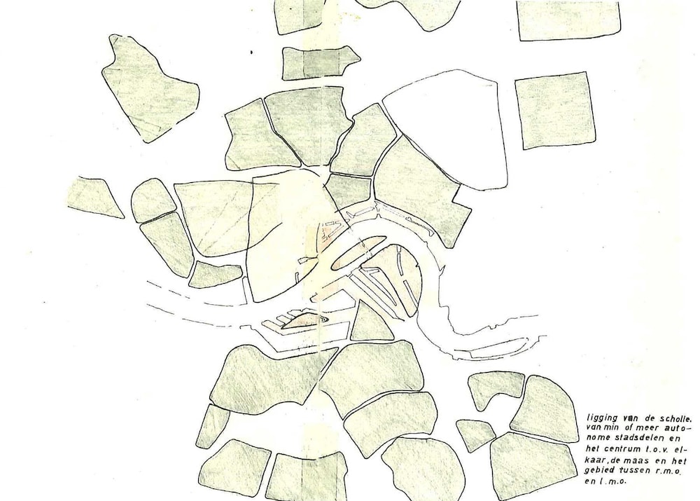
Whether in the centre, in the suburbs and in its peripheral residential settlements in all the urban areas that compose Rotterdam there is a perception of it being a city of the future. Like many metropolises, Rotterdam, though not large, is not a compact city. It is a group of dissimilar and coexisting realities, in which the variations of the urban character are accentuated by how far each reality is from the port and the degree of commingling of the multiple functions. As Kees Christiaanse, one of the Netherlands’ foremost architects maintains, «Rotterdam does not have a centre like other cities, but is rather a decentral configuration of central locations (“hearths”) in the form of urban quarters, ensembles or significant public buildings» (Christiaanse, 2013: 10) (fig. 2). The image of this polyhedral city, developed in fragments with its urban struggles representing planning laboratories, is emphasized by the freedom to experiment of large, mainly Dutch, studios, that have made of Rotterdam a stimulating playground. In fact, Rotterdam is almost a manifesto of the development and affirmation of the architectural currents of the Netherlands, a sort of architectural portfolio in real scale designed by the most important Dutch studios including OMA, MVRDV, KCAP, West 8, Mecanoo and many others. Rotterdam’s charm tells the story of a capital of modern architecture, of a city that knows itself to be both resilient and a perpetual construction site for the metropolis of the future.
From construction site to metropolis. The genesis of a phoenix-city
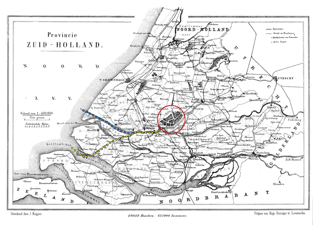
The original village of fishermen who settled on the Rotte River around 1270, began to grow into a dynamic port city of merchants during the 17th century. Following the opening of the Nieuwe Waterweg: a navigable canal that connected Rotterdam to the North Sea (fig. 3) around the end of the 1800s, the port grew bringing with it economic and urban development and changing the city into a “transitopolis” (van de Laar, 2013). As it became necessary to expand the port facilities in 1887 the Public Works Department established that the city and the port would follow two axes and develop differently.
(Fig. 3) Map of the province of Zuid-Holland, 1865-1870. In red: Rotterdam, in blue: the artificial canal (Nieuwe Waterweg), in yellow: the route that commercial naval traffic had had to follow before the artificial canal was constructed. Elaborated by the author. Source: commons Wikimedia.org
To guarantee a relationship of pacific coexistence between urban expansion and infrastructure, the city expanded toward the west with the construction of new island neighbourhoods while the port extended toward the south, occupying the southern bank of the river, in the area of Kop van Zuid (South Cape). In the first two decades of the 20th century, with both its population and traffic increasing, Rotterdam decided to move forward along the path of development, offering itself, even before the sad events of WWII, as a modern city open to change and not bound by its historic roots. In fact, the industrial landscape surrounding its harbour had always had a central role in the city’s image and character, both with modern and futuristic orientations. In Rotterdam, cranes, ships and the harbor basins have greater iconic and identity value than bell towers, towers and squares. No one is surprised that after the destruction of the inner-city on May 14th 1940, Rotterdam’s answer was to use this tabula rasa to their advantage and to undertake a reconstruction based on a new image of modern metropolis. The city had already started to embrace and promote this image in the 1920s with new social housing districts, the trademark De Hef Bridge, the Café De Unie and the famous Van Nelle building, an icon of modern industrial architecture.
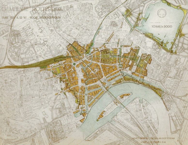
Only a few months after the bombardment, Rotterdam reacted quickly to the damages of WWII, proposing a “Reconstruction Plan” of the centre drawn up by engineer Willem Gerrit Witteveen and approved in December 1941 (Fig. 4). The plan did not revolutionise the urban space, rather, it restricted itself mainly to the development trajectories initiated between the wars and essentially represented a continuity of thought unscathed by the sad events of the war. The plan called for the preservation of a few buildings (the Post Office, the Laurenskerk, the Schielandhuis, the Witte Huis), the creation of wide streets to allow for an increase in vehicle traffic and the planning of regular block-like buildings. In 1944, Cornelis van Traa, Witteveen’s assistant modified the plan accommodating the growing trend toward modernism in vogue among architects of the period. Van Traa’s “Basic Plan” (Fig. 5) was approved in 1946: a new reconstruction plan focused on wide streets and zoning based on function that established that the “citadel” of services would be built in the inner-city. These would include economic and recreational centres, while peripheral areas would mostly be reserved for residential purposes.
(Fig. 4) Reconstruction Plan, 1941. Source: wederobouwrotterdam.nl
(Fig. 5) Basic Plan, 1946. Source: wederobouwrotterdam.nl
Between the 1950s and the 1970s Rotterdam was provided with all the necessary infrastructure for urban growth and its affirmation as a metropolis. A high speed ring road called Ruit (diamond) was built around the urban centre. It allowed for easy access to the city and connected it to the main international networks that then became the model for the building of the national transport network (Frijhoff & Spies, 2004). In 1968, the Netherlands’ first metro was built here and it has the record for being the world’s shortest metro, less than 6 kilometres. It connected the area of the central station to the area south of Zuidplein crossing the city perpendicular to the river. Also the port expanded to receive refineries and fuel deposits in the new areas of Botlek (planned in 1947), Europoort (1957) and Maasvlakte (1964) constructed on land that had formerly been used as agricultural land or left as natural habitats on the island of Rozenburg (Botlek and Europoort) and by constructing on new artificial land (Maasvlakte).
Reconstructing a cultural framework. The myth of the ‘New Rotterdam’
The infrastructure boom of those years accentuated the city’s image for modernity. It was becoming increasingly important on the international economic scene, and this vitality provided the cultural humus that nourished and led Rotterdam in the 1980s. A change that was sweeping cross Europe, cities steadily moving from the functionalist approach that had guided city transformation and they were placing increasing attention on adapting spaces to satisfy the needs of everyday uses and practices (Meyer, 1999). In Rotterdam this move to approach city planning ‘culturally’ meant creating a new type of infrastructure that would incentivize the popularization of the arts and the moments of social encounter, in other words, museums, galleries, theatres and spaces for events. In 1985 an attempt was made to design a unitary view of the city and the “Binnenstadtsplan” was approved. This new plan for the inner-city reformulated some of the concepts contained in the 1944 and 1946 plans – the green wedge planned by Witteveen and the valorisation of the relationship with the water (‘window on the river’) desired by Van Traa – and they were inserted into the effort to push a cultural renewal through the creation of new locations for the divulgation of the arts and the identification of areas for urban expansion and regeneration. The plan called for the development of four areas, each with its own ambition and vocation: the City as an administrative centre; the “green” or cultural triangle to the south-west, where museums would be located; the Waterstadt (water city) to the south-east for the development of maritime tourism and Kop van Zuid, a former port area, mostly for offices.
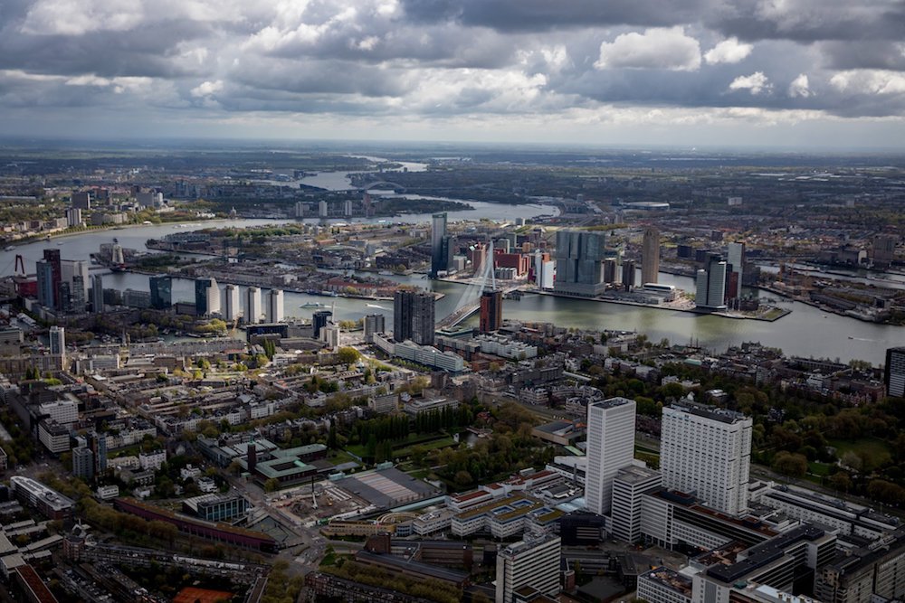
The plan attempts once again to focus on the organisation of the city “as a whole” (van Ulzen, 2007) avoiding fragmentary interventions and aiming at creating a new unitary image for the city. When the new urban projects were presented to the people in reports, articles and events they used the slogan “The New Rotterdam”. This image of “The New Rotterdam” became reality between the late 1980s and the first half of the 1990s in the redesigning of the old port area, OudeHaven and Leuvehaven, in the erecting of a new Maritime Museum, in the reorganisation of the historic Boompjes (the path along the river bordered now with new residences and offices), in Schouwburgplein the large square for events with the Imax theatre, in the museum park with the planning of the Het Nieuwe Instituut and the building of the Kunsthal. Aside from these significant interventions to mend the urban centre and render it more functional, in 1987, came the plan to requalify the area of Kop van Zuid (fig. 6). This intervention was Rotterdam’s first project of urban renewal and it was among the first European experiences in waterfront regeneration. The former port area was conceived as a real extension of the city on the other side of the river. In fact, if with the requalification of the city’s southern façade, in the area of the historic docks, Rotterdam had promoted dialogue with the water as an urban element, after the recovery of Kop van Zuid the river becomes part of the city itself, a liquid boulevard, a favoured area from which to enjoy wide panoramas, a connecting element between the two banks crossed by bridges, boats and water-taxis. The river acquired a new role giving new meaning to the southern area which was historically less urbanised as its development was only in relation to the industrial port activities. Following the model Baltimore used in the regeneration of its waterfront, the only clues to Kop van Zuid’s former identity as a port area is in the shape of its piers and in a few buildings preserved as memories of its past (e.g. the former terminal of the Holland-American Line and the ex-warehouse on the Entrepothaven). The masterplan of the area near Wilhelmina Pier, presented in 1991, called for the construction of skyscrapers containing offices and residences that then gave the entire city the nickname of “Manhattan on the Maas” underlining the metropolitan character of the Dutch city. In this period, putting itself forward as an alternative to Amsterdam, Rotterdam inaugurated a strategic marketing plan to attract tourists and the city continued to metamorphose from an industrial centre to a city of culture (Buursink, 1999). Using its strong points like water, architecture and culture, Rotterdam has been able to react to the crisis in the industrial sector and to reinvent itself as it pursues new objectives, to the point that in 2001 it was chosen as “Cultural Capital of Europe” exalting the occasion, through a series of events, above all the multiculturality of its population.
(Fig. 6) Rotterdam toward the south. View from Museumpark (in the foreground), the area of the Boompjes (to the east) and Wilhelmina Pier at the top to the west). Author: Josh Haner.
Between adaptive strategies, architecture and urban regeneration. Rotterdam, the city that dares (still)
Still today Rotterdam is solid evidence to the efficiency of resilient planning, able to modify its approach coherently to varying economic, social and environmental needs. The city’s reaction to natural risks such as flooding, to which it is subject (in particular following calamitous events that occurred in the 1950s and between 1993 and 1995), was first to invest in protective engineering works – based on the specifications in the Delta Plan – and then to adopt adaptive strategies as established in national and regional documents (Lu & Stead, 2013). Rotterdam was identified as a “critical location” by the Delta Commission Report of 2008 for the implementation of policies focused on climate change and for this reason, since early this century it has directed its planning programs toward identifying suitable strategies and valid projects to best manage its water courses. In this regard, in 2005, the second IABR (International Architecture Biennial Rotterdam) focused on the theme of water and the relative risk of flooding by placing the role of city planning and the design of adaptive spaces at the centre of the scientific and institutional debate. The issue was brought to those drawing up the “Rotterdam Waterstad 2035” Plan in which the subject of water is completely overturned. ‘Water as a threat’ is changed into ‘water as a resource’ projects promoted different spatial solutions – such as floodable squares and green roofs – discussed and illustrated on a metropolitan scale and using technological means. Resilient strategies are pursued not only using planning instruments such as the “Rotterdam City Vision 2030”, the “Waterplan 2 Rotterdam” and “Rotterdam Port Vision 2030”, but also with local programs, as in the documents “Rotterdam Climate Initiative”, the “Rotterdam Resilient Strategy” and the “Rotterdam Programme on Sustainability and Climate Change 2015-2018”, that seek to establish eco-sustainable objectives through agreements among various agencies (e.g. Municipal Government and Port Authority) and private companies, also by educating the population to a new approach in the planning of resilient spaces, in the use of technologies for renewable energy and in projects to reduce everyday consumption.
Thanks to a will to invest in resilient planning, the city’s space continues to be dynamic and a work in progress. The multiplicities of the forms that characterise the metropolis, the chaos of volumes that distinguish it, though representing the weaknesses of a unitary design never totally implemented, have given to Rotterdam the courage to project itself toward the future, refusing mild prudence as it reaches out to change and offers itself as a field for experimentation for research on urban space. Furthermore, the flexibility and farseeing qualities of the urban policies it has adopted, place Rotterdam at the centre of the debate on the future of planning as we saw at the third “Cities Forum” which the European Commission organised in November 2017 right in Rotterdam.
An overall picture of the projects which have left their mark on the city in recent years and which will continue to transform it in the near future, gives one a wide and variable approach to projects which pay great attention to context and to the objectives delineated by the urban strategies. In fact, if on the one hand Rotterdam continues to construct iconic buildings in its urban centre – differently from what happens in the rest of Europe where architectonic and urban projects have become more limited in scale and more peripheral – on the other hand there is no lack of slow, meticulous interventions, careful as they recover and reuse spaces and infrastructure.
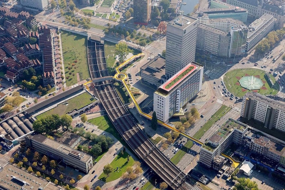
The Markthal by MVRDV (2014), the Timmerhuis by OMA (2015) and the on-going expansion of the Boijmans Museum (2018) by the MVRDV Group, are examples of fertile urban policy that is increasing the city’s metropolitan dimensions and giving it new tourist and economic focal points. Besides, the projects connected with infrastructure nodes shift between substitution and recovery. These nodes are reinterpreted in contemporary terms to adapt them to the new flows of passengers that using them to reach outlying areas. The Central Station by Benthem Crouwel Architects, MVSA and West 8 totally changes the view of the city for arriving rail passengers. It was inaugurated in 2014 to substitute the previous station built in the 1950s. Instead, for the viaduct of the old Hofplein station northeast of the centre, a plan has been agreed on by an association of private companies, a group of citizens, the national railway group and the Municipality of Rotterdam which will restore to it functions similar to those found in the original plan. This project, to be constructed in phases, aims to requalify the neighbourhood locating boutiques, bars and restaurants in the abandoned arches of the viaduct (a project by PEÑA architecture and AFARA, 2011) and to build, in the near future, an urban park on top of the viaduct, where at the moment there are only unused rail tracks. Another winning aspect of this requalification project is an elevated pedestrian walkway the Luchtsingel, that allows access to other parts of the central station by passing over elements that otherwise represented discontinuities: roads, tracks and platforms. The Luchtsingel project started as part of the “Urban Initiative” launched by the city of Rotterdam in 2011 whose objective was to implement requalification projects proposed by citizens. The winning project, designed by ZUS has at its heart a long elevated walkway in wood connecting the central train station, the roof of the building Schieblock (an area open to public use with a garden and a café), the Pompenburg Park and the Hofplein area (fig. 7). The construction of the walkway was partially financed by a crowdfunding campaign which has given the work a social meaning: though managed by the administration, it belongs to the collectivity.
(fig. 7) View from above of the Luchtsingel walkway. Source: v8architects.nl
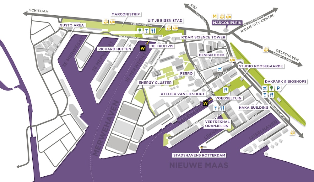
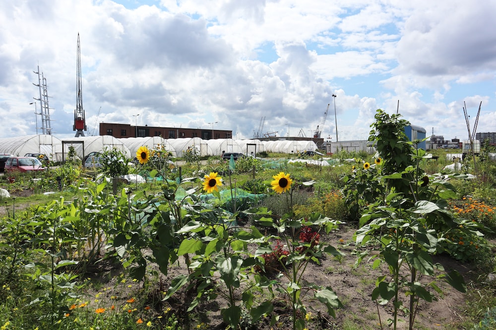
The collaboration between institutions and other stakeholders is at the base of all the urban transformations carried out in Rotterdam. In particular, the capacity to build solid institutional synergies when defining urban requalification projects is evident in the reconversion which started in 2002 in the Stadshavens port area. Here the public administration collaborated with the Port Authority, NGOs and private companies to define prospective future uses for the area, preparing a strategic planning document called Structuurvisie. West of the city centre, the Vierhaven and Merwehaven piers (north of the river) and portions of the Waalhaven and Eemhaven (south of it) will be modified to host entities whose functions will be either educational or start-ups and small companies in sustainability research – compatible with pre-existing volumes and spaces – a process which has already been initiated with the founding of the RDM Campus in the ex-warehouses of the Rotterdam Dry Dock Company and the creation of a ‘Skill City’ in the northern area called M4H in which there are research laboratories, spaces for temporary events, gardens and new public spaces (fig. 8 & 9).
(Fig. 8) Requalification scheme of the M4H area. Source: “Summary of the development strategy for Merwe-Vierhavens, Rotterdam”.
(Fig. 9) Urban gardens in the M4H area. Photograph by the author.
“What’s Next?” Along what trajectory are contemporary projects taking the city as it moves into the future
Observing the ample and fervid panorama of projects, Rotterdam has shown an evolutive continuity of urban forms, spaces and relations that continue to emerge and take up contemporary challenges. Describing the city through emblematic interventions on the one hand emphasises their eclectic qualities and on the other their fragmentary nature. But the lesson to be learned from Rotterdam is that we must have the capacity to respond to the issues and challenges of the future with plans and projects. It is from this point of view that the dossier will attempt to recount the Dutch city through four project and contemporary approach experiences that respond to central and recurrent themes in Rotterdam’s history. New strategies for sustainable planning are treated in the contribution of Tillie (Delft University of Technology) that, analysing the “Rotterdam Waterstad 2035” with the hindsight of the last 12 years, will point out how the planning of Rotterdam’s spaces has evolved together with the objectives and directives linked to the paradigm of water as a resource. Following on this, the project “The River as a Tidal Park”, contains a descriptive presentation from the designers Strootman Landscape Architects, and focuses of the sustainable planning and design of the contact areas between the water and the land, between the river and the city. The project “Archipelago of Knowledge”, commissioned by several public bodies in 2016 from a group of planners (among which Openfabric) and coordinated by Deltametropolis, is based on a different way of looking at the water theme. This project is part of the complex search for innovative solutions to redesign the delicate city-harbour relationship which De Martino (Delft University of Technology and the University of Naples Federico II), Garofalo (Openfabric) and Hein (Delft University of Technology) treat in their contribution. Finally the creation of new public spaces initiated and supported by local communities is looked at by Janssen and Nagelkerken (Dakpark Rotterdam Foundation) as they describe the construction and management of Dakpark (designed by Buro Sant en Co), a park built in 2014 on the roof of an extensive commercial building in area of M4H, formerly part of the port.
As we follow the story of Rotterdam starting in the past and moving through the present and into its future, we note the central role of city planning in the definition of spatial, cultural and social transformations. Among the experiences that Rotterdam has adopted, emblematic factors such as scientific search for new strategic approaches, cooperation among the various actors in the decision-making processes are placed at the base of the planning instruments and the development of sensitive initiatives aimed at mending territories inhabited by the weaker parts of the community. Pursuing these principles, Rotterdam has never stopped innovating and investing in itself and in the planning of its spaces as a necessary means to guaranteeing a high quality of life to its citizens. An awareness of the issues that still confront the territory – like how to combat climate change, social unease due to high levels of unemployment, and important disagreements in the city’s governance resulting from its ambition to be at one and the same time Europe’s first port and a livable and attractive city – mean that today’s Rotterdam is still a metropolis in the making, changing its appearance rapidly and renewing itself continually and adapting to and challenging the future.
Bibliography
Buursink J., (1999), "The cultural strategy of Rotterdam", in Cybergeo: European Journal of Geography.
Christiaanse K., (2013), Rotterdam, 010 Publishers, Rotterdam, NL.
Faludi A., van der Valk A. J., (1994). Rule and Order Dutch Planning Doctrine in the Twentieth Century (1994 edition). Springer, Dordrecht, Boston.
Frijhoff W., Spies, M., (2004), Dutch Culture in a European Perspective: 1950, prosperity and welfare, Uitgeverij Van Gorcum, Assen, NL.
Lu P., Stead D., (2013). "Understanding the notion of resilience in spatial planning: A case study of Rotterdam, The Netherlands" in Cities vol.35, pp. 200–212.
Meyer H., (1999), City and port: urban planning as a cultural venture in London, Barcelona, New York, and Rotterdam: changing relations between public urban space and large-scale infrastructure,International Books.
van de Laar P., (2013), "Modernism in European Reconstruction-Policy and its Public Reception, 1945-1970: The Rotterdam Case". In G. Wagner-Kyora (Ed.), Rebuilding European Cities: Reconstruction-Policy since 1945, Franz Steiner Verlag, Berlin, DE.
van Ulzen P., (2007), Imagine a Metropolis: Rotterdam’s Creative Class, 1970-2000, 010 Publishers, Rotterdam, NL.
EWT/ EcoWebTown n.16
Journal of Sustainable Design | Rivista semestrale on line - Online Six-monthly Journal
Edizione Spin Off SUT, Sustainable Urban Transformation, Università Chieti-Pescara
ISSN 2039-2656 Registrazione Tribunale di Pescara n° 9/2011 del 07/04/2011