Il rapporto tra Sostenibilità e Innovazione tecnologica nella progettazione dell’ambiente urbano a cura di Filippo Angelucci
torna su
Oman Live: an Ecological Reading for a “Differently Sustainable” Urban Project in the Gulf
Francesca Arici

Francesca Arici
Keywords:
Oman – Muscat - Professional Practice – Zoning – Ecological Hermeneutics – Sustainability
Abstract
Among the GCC countries, Oman is in many senses an exception. This essay presents a methodological extract from the on-going urban project for Matrah, one of the oldest commercial settlements in Muscat (Oman).
The focus is on the “ecological reading” of the project area (about 470 ha) performed by the work team during the initial phase of the Concept Design, in an effort to comply with the early request made by the Client to produce a zoning for the area. The answer to such a request unexpectedly produced a fertile interpretative tool, able to address the complexity of the area and to trigger the production of a dynamic urbanistic project, currently in progress.
The use of an extended notion of ecology, as per Banham’s acceptation, enabled the work team to gain a deep grasping of the project area while providing, together with the help of more conventional cognitive techniques such as fieldwork, historic research and data collection, the proper starting point for a “differently sustainable” urban project. One grounded on the understanding of Matrah’s soul and of its 6 ecologies.
Francesca Arici
As a live-report from an ongoing experience, this essay presents a methodological extract from the urban regeneration project for Matrah, one of the oldest urban settlements in Muscat (Oman).
The focus is on the “ecological reading” of the project area (about 470 ha) performed by the work team during the initial phase of the Concept Design, in an effort to comply with the knowledgeable but somehow premature request made by the Client to produce a zoning for the area. The answer to such a request unexpectedly produced a fertile interpretative tool, able to tackle the complexity of the site and to trigger the production of a dynamic and layered urbanistic project, currently in progress.
The use of an extended notion of “ecology”, as per Banham’s acceptation, enabled the work team to gain a deep comprehension of the project area while providing, together with the help of more traditional cognitive techniques such as fieldwork, historic research and data collection, the proper starting point for a “differently sustainable” urban project. One grounded on the understanding of Matrah’s soul and of its six ecologies.
Context
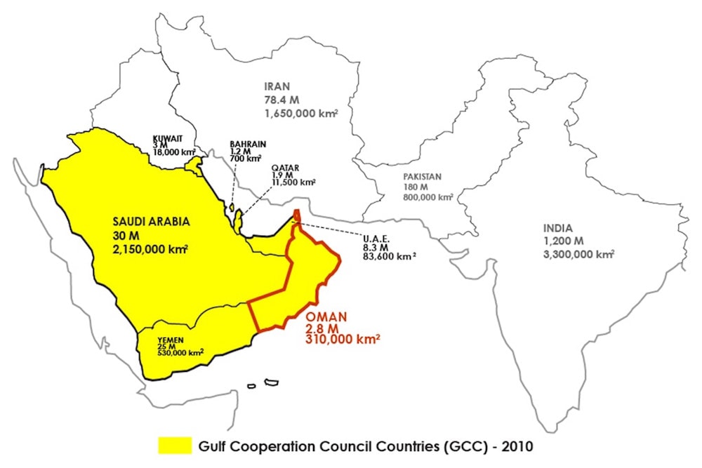
Among the GCC countries, the Sultanate of Oman is “different” under many aspects.
As a first note, Oman does not compare with the average GDP/pro capita or the percentage of urbanized population of its richer cousins. With its large territory of approximately 300.000 km2 and a (fast growing) population of about 4 millions, its population density is extremely low.
Most notably, many cultural peculiarities characterize this country. Oman has always been in touch with its sea as much as it has been with its inland: a long seafaring tradition characterizes its civilization, resulting in a culture accustomed to exchange and respectful of “diversity”. The national attitude is a gentle, elegant and peaceful one.
Because they possess a long history, Omani people are genuinely attached to their traditions although sometimes this fact results in unwanted outcomes. Land consumption and sprawling urbanization due to the irrefutable rejection of high-rise building are one of the most visible examples.
The political context is an autocratic yet enlightened one, which since the 1970 has lead the country through a process of quiet and steady development hinged on the provision of a modern health system, public education and an ever-growing road network. While a modern and sound juridical system has been established, the same cannot be said about urban planning, still lacking a structured and coordinated legal framework.
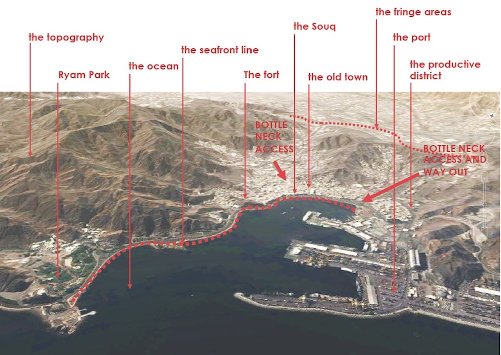
On this background, the urban regeneration project for Matrah consists of an integrated master plan for one of the oldest part of Muscat, the capital city of the Sultanate. The project area covers approximately 470 hectares with a current population of 31,000 inhabitants. It includes both the historic settlement and the newer areas along the metropolitan highways. The current demographic trend records a typical phenomenon in global historic centres: general decrease of local population, with wealthy Omani families relocating into more attractive residential areas of Muscat, and expatriate working class colonizing the decaying urban fabric.
At the same time the area is exceedingly lively, due to the presence of the oldest and most active Omani souq and the characteristic urban pattern, essentially pedestrian.
The extremely dense fabric of the historic town constitutes, in fact, the most distinctive trait of Matrah, “the only part of Muscat featuring a historic urban pattern in use” (Klozoris, 2011, p. 33). A Chinese box game of uniqueness within the uniqueness.
Objective: a “Diverse Sustainability”
Matrah urban regeneration project is challenging for a number of reasons.
First of all the stakeholder map includes a multiplicity of actors spanning from the institutional, to the utility authorities, the local communities and the entire nation, due to the significance of the place. Governance is therefore a key issue, in absence of a purely democratic framework.
Secondly, it encompasses the whole scope of the urban professions, including planning, heritage conservation, real estate, urban design of the public realm, landscape, communication and community involvement as well as the design of all the infrastructure networks (road system, drainage, water supply, sewerage, electricity, telecommunications, etc.). Several disciplinary contributions are involved and a highly trans-disciplinary approach is required.
Furthermore, the multi-layered sensitivity of the area as well as the amount of involved interests make any change very difficult to be agreed upon, in absence of a truly shared vision grounded in knowledge and able to convince.
Arguably, thanks to the complexity of the scope, an adequately thick notion of sustainability can be addressed here and applied as an operative tool rather than as a flat political slogan or a business brand. Differently from the neighbouring Golf Countries, no global “star architecture” will do here (Ponzini, 2011), nor any tabula rasa of zero-carbon new towns.
Method: Challenging the Common Understanding of “Zoning”
Here it comes the request to provide a zoning before the site analysis process had even started and in absence of a proper regulatory framework.
The term “Zoning”, as the single most widely used tool within the discipline of Urban Planning, refers to the “legislative process that divides privately-owned urban areas into different zones according to the specified land use. Each zone is regulated as to the density, location, size, and type of buildings permitted therein” (www.businessdictionary. com). Since the start of the last century, zoning has been the primary tool of western urban planning. Nevertheless, we all know that this merely functional approach has too often proved unsuccessful in too many urban contexts. According to R.K. Lewis (2006), “Urban design thinking and practice have greatly advanced over the past 30 years. Unfortunately, conventional zoning, the crude but all-powerful regulatory tool shaping cities, has changed little. Given the need to transform land-use planning and development, why is it so difficult to transform conventional zoning?”.
The big opportunity, in this context, was formulating a different system rather than changing it. The ecological lens was then applied as a useful conceptual tool to dynamically understand the different macro-systems present on the project area, as well as their interactions.
The notion of ecology was obviously employed within the extended Banham’s (1971) acceptation, as the product of the interaction among geography, climate, economy, demography, technology and culture. In this sense, the sea, the mountains, the port, the highway system and the built fabrics can be all be considered urban ”ecologies”. If the city is understood as a dynamic complex ecosystem, then its infrastructures have the power to create certain growth patterns and architectures can be better understood in relation to that larger condition. The ecologies, in this sense, act simultaneously as product and producer of the city’s infrastructure, which, in turn, becomes a foundational element of the city.
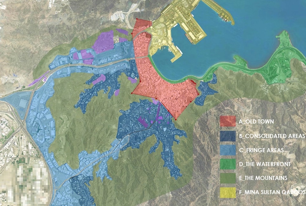
The ecological “macro-zoning” was born this way, as the effort of both understanding and projecting a first regulative intention on the project area, by recognizing its main features and the associated behaviours: the old town inside the wall, the consolidated areas, the fringes, the mountain, the waterfront and the port.
In defining the “zones”, attention was paid to specific territorial factors such as history, physical and environmental features, land use, urban morphology, community boundaries, road patterns, etc.
The ecological lens helped understanding, for any identified zone, their main organic infrastructural characteristic and, more interestingly, the conditions and interactions which happen on their overlapping borders.
Macro-Zoning: the Six Ecologies of Matrah
Through this process, six macro-systems were then identified and described, being the use of the term “zone” instrumental to the purpose:
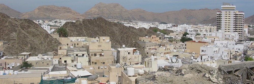
Zone A. The old town: has a definite urban form, skyline and urban pattern, characterized by a net prevalence of the built mass over the empty space, by the presence of many heritage buildings and by a generally harmonious relation with its environment. At the same time, it shows its fragility in its degraded buildings, in the traffic congestion deriving from the imperviousness of its pattern to vehicular access, in its evidently decaying condition. It is one the most vulnerable and precious part of Matrah, and preserving it as the historical centre of Greater Muscat will be one of the main tasks of the master plan.
Zone B. Consolidated City: includes some heterogeneous historic neighbourhoods of the city located outside the wall boundary, characterized by a more sparse traditional settlement pattern, highly transformed over time. These settlements were often born at the same time as the old town as barasti house villages; some of them also contain a few heritage buildings. Initially located on flat areas usually on wadi valleys, they have grown over time on the mountain slopes. Most of them are quite densely built and populated, generally by low-middle income households, and possess a slightly higher degree of permeability to cars than the old town; their open space usually lacks any quality. They have the potential to become pleasant medium-density residential neighbourhoods with minimum transformation of plot sizes and building typologies.
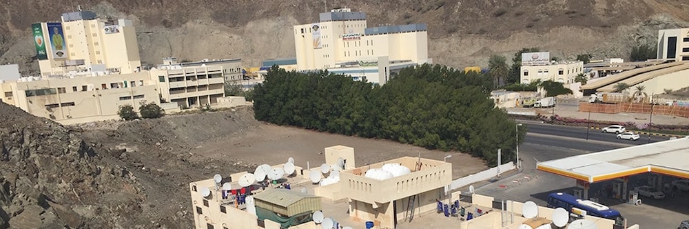
Zone C. Fringe Areas: these areas are the most recently developed and are characterized by their relation with the big scale infrastructure of the metropolitan highway system. The disorderly distribution of buildings and land uses contributes to create a poor urban quality and generates land use conflicts. At the same time there is great opportunity in the zone, because it still contains developable land, a very scarce resource within the historical centre and the consolidated areas.
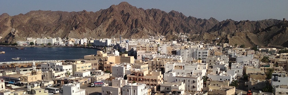
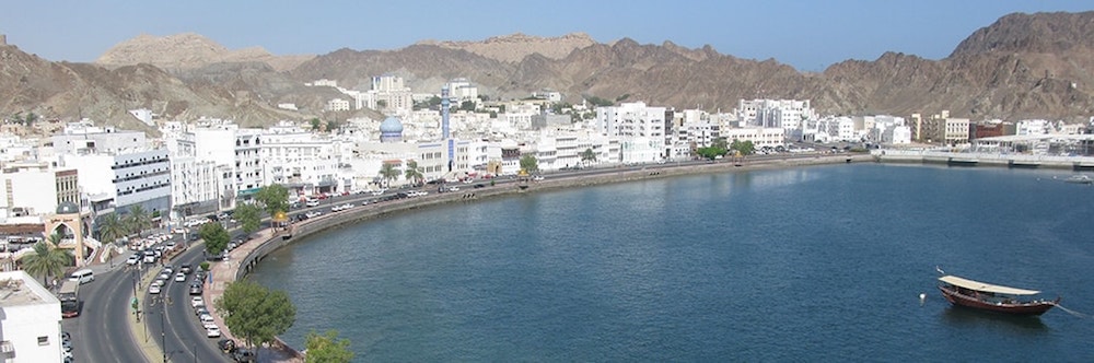
Zone D. Waterfront: is the zone where the city touches the ocean, the founding element of Matrah, the source of its economy and of its identity. The Corniche road, built through land reclamation in the 1970s, runs all along the waterfront challenging the relation with the sea because of the fast vehicular flows and the traffic jams at peak hours. Nevertheless, in terms of urban and landscape image the waterfront still maintains an outstanding aesthetic quality, provided by the breath-taking view of the Matrah bay surrounded by its sculptural mountains and by the white skyline of the Corniche facades.
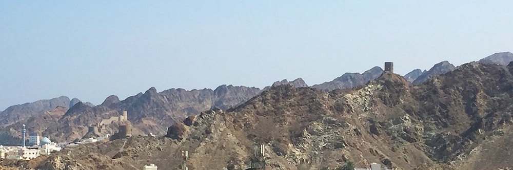
Zone E. Mountains: Matrah is characterized by a unique skyline, outlined by its mountains profile. This is a delicate and central zone of the project area, the one that most of all creates the distinctive image of the town. Currently, the search for new developable land is causing an aggression to this valuable feature, putting at a stake both the aesthetic and the naturalistic potential of the area. While a properly located development could even increase the beauty of the landscape, some areas are to be integrally preserved due both to an environmental and a visual rationale.
Zone F. Sultan Qaboos Port: this large infrastructure built in the 1970s completely altered the original relation of Matrah with the sea, almost doubling, through land reclamation, the original extension of dry land. After its construction, the port provided for decades great economic boost to the commerce in Matrah, until today when the decision was taken to relocate its commercial activities to Sohar. Mina Sultan Qaboos will be redeveloped into a touristic and residential hub, a massive development that will have a deep impact on Matrah. The main challenge thus becomes the creation of a synergy between the two - differently managed – developments.
Interactions
In exploring the edge conditions generated among the different zones, the macro-zoning tool proves its cognitive efficacy.
The interactions along the intersecting borders disclose several special conditions to be addressed by the project with particular attention. Where the built areas climb on the mountain slopes, where the old town meets the waterfront and the port, where the highway gets close to the consolidated areas, where the mountains face the highway… those are the places where the highest transformation and regeneration potential exists and must be tackled.
That is the way to discover the hidden space needed to make room for a sustainable urban transformation.
References
Banham R. (1971), Los Angeles, the Architecture of Four Ecologies, Berkeley: University of California Press.
ETH Studio Basel, German University of Technology in Oman (2015), Muscat and Oman - Engineered Land: A Territorial Research, Zurich: ETH-Zürich.
Klozoris A. (2011), ReThink Mutrah, Aachen: University of Aachen.
Lewis, R. K. (2006), “Working Toward a New Understanding of Zoning”, in Eddyburg, http://archivio.eddyburg.it/article/articleview/6125/0/227/.
Ponzini, D. (2011), “Large Scale Development Projects and Star Architecture in the Absence of Democratic Politics: the Case of Abu Dhabi, UAE”, in Cities, 28(3), pp. 251-259.
Soloman S.F. (2013), Good Governance and Sustainability in Residential Land Administration in Muscat, Oman, Berlin: Technische Universität.
EWT/ EcoWebTown 12 - I 2015
Magazine of Sustainable Design
(Quadrimestrale on line sul progetto di città sostenibile)
Edizione SUT, Università degli studi G. d'Annunzio Chieti-Pescara
Registrazione al tribunale di Pescara n. 9/2011 del 07/04/2011