Back to territory. Positions and forms of sustainability in Germany edited by Jörg Schröder and Maddalena Ferretti, with Claudia Di Girolamo
torna su
The Regional City. From residing to living
Miriam Mlecek

Miriam Mlecek
Introduction
To refresh our perspective of the city and to connect the smart city factors and the natural resources agenda with an emphasis on the cities´ potential of resilience we need to include a comprehensive approach to consider everything the city consists of, produces, expels and demands- and to look at the reality of the city and its implications for design and planning.
A victim of the urban era euphoria, challenges beyond the major cities fall into oblivion. However, a large proportion of people are living in the periphery. Although now, designs for intermediate cities, sprawl and Edge Cities are on the rise, there is no current vision or conception for these locations.
In some cases this means often an unexpected and surprising peripheral juxtaposition of uses and activities on the fringe of a metropolis. A great spatial potential exists, but does not come to the course. Sectoral and administrative "blinders" stand in the way of networked potential. The activation and pooling of existing resources and addition of missing programs has to be the aim with new “business and network” models for a community being a possible output.
The regional city in the metropolitan fringe has to be a place of new goals and visions of the future for regional and local identity. The large suburban areas on the outskirts bear the potential to become a case study for strategy development. Innovative future visions and ideas for the community and the adjacent places should help the regional city evolve from a place of residence to a place of living - with prospects for regional, site-specific vascular systems, to achieve independence and a unique place for developing a “branding” on social, economical, lifestyle- and resource based parameters.
In light of these facts, some fundamental questions arise: What development opportunities does a regional city have nowadays? What role does an urban fringe area play in the region? What forms of mobility are available? Will there be a functioning public transport in rural areas, if the individual ranges of motion of the aging population will become smaller? What are the points of contact between urban area and countryside? What planning tools can create opportunities and spaces? What are regional residential areas of the future? How can economic activities be tied to villages? Will there be a renaissance of agricultural management for a self-sufficiency? And will there be blossoming sugar beet for ethanol production in the front yards?
Depicting the Region
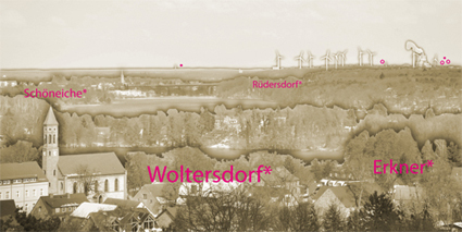
Brandenburg is part of the the outskirts of Berlin. Berlin is the metropolis in the center of Brandenburg. Since 1989, profound structural changes have been taking place here: the fall of the wall, the failed consolidation of a merged state Berlin-Brandenburg in 1996, excessive expectations towards Berlin as the capital, the rapid colonization of the cities fringe with model homes, the fight against structural degradation and demographic changes in the countryside are different stages in a chequered history influenced by regional needs and – often improvised – communal intentions. The result was known in the 90s as the "commuter belt"– places with a lot of (spatial) potential that is barely being used. Therein, the peripheral area on the outskirts of the towns Erkner- Rüdersdorf-Schöneiche-Woltersdorf is an example for the need to redefine regional and local identity. „The Regional City" concept can be a test ground for the creation of future scenarios for the metropolitan fringe.
The goal would be to develop spatial and organizational strategies to provide exemplary approaches that can be transmitted to other peripheral areas in Brandenburg an beyond. Potential should be identified and developed into a comprehensive strategy. For example; both the access to the transport network in Berlin, as well as unique scenic qualities could be combined to create a place with attractive suburban advantages. The promotion of quality of life, connection of living and working and intergenerational living and social concepts has to be tested and worked out as examples in scenarios. Both "traditional" spatial planning, and organizational strategies are combined and developed into scenarios. From this starting point, considerations of the local situation and the adjacent communities shall lead towards cross-border solutions and the formation of a stronger regional identity.
At a time when GIS has become the default-mapping tool, experiential and more qualitative factors are disappearing from depictions of the region. Landscapes and settlements are increasingly described only by those factors that are readily quantifiable: the physical elements of roads, buildings, rails, volumes,agricultural land and open vacant spaces, bounded areas of protected habitats, natural beauty and special conversation; designed zones of economic activity and areas of shared public usage. There is the need to establish new architectural drawing methods to return the qualitative to these depictions and in so doing to advance GIS as a core tool for planning the future of the regions. These challenges will also be connected with the exploration of the role of mobile services in the creation of new maps and overviews of territorial "digital node".
Connecting a suburban conglomeration with an urban market could open new dimensions for trade relationships of regional production and agriculture into or via a "transfer" space in the urban environment such as the Tempelhofer Feld in Berlin for example, on a virtual level or via “market apps”. The grocery markets for regionally produced food are on the rise and being hosted in public places in the city to be sold in the urban context to the rather disconnected city inhabitants. The approach to connect this strategy with modern mapping and communication or ICT systems becomes a new model in regards to the ideas of regional economies and their interrelation between the location of production and the location of trade. A mapping tool in addition to mobile network analysis technologies which could be tested in both environments, the regional and the public space, could bring out different qualities complementing each other. Additionally, in parallel to established rail and road networks, other networks of interdependency that have emerged around the newer-generation economic activities and recreational activities could include upgraded mapping tools and communication /ICT technology. This strategy might lead to improve the functioning of these networks to be coupled with innovative mobility models; addressing vehicle type, energy source, route selection and more.
Therefore, the promotion of quality of life, connection of living and working, inter-generational living and social concepts as well as re-activation of agricultural aspects needs to be tested in diverse scenarios. These scenarios should be build upon a spatial and economical analysis as well as providing existing development projects a new perspective while transforming the regional city to bring out local and independent potential with regards to lifestyle and behaviour within the modern, flexible and technisized conditions of daily commuter life.
EWT/ EcoWebTown 10-11, II-III 2014
Magazine of Sustainable Design
(Quadrimestrale on line sul progetto di città sostenibile)
Edizione SCUT, Università Chieti-Pescara
Registrazione al tribunale di Pescara n. 9/2011 del 07/04/2011